GEOINT 2022 attendees invited to experience Sit(x) demo featuring analytics of Ukraine
New Hartford, NY – April 20, 2022 –PAR Technology Corporation (NYSE: PAR) today announced that its wholly-owned subsidiary PAR Government Systems Corporation (PGSC) has incorporated BlackSky’s (NYSE: BKSY) commercial satellite data into the Sit(x)™ cloud-native situational awareness suite making it possible for tactical and operational end users to access near real-time imagery on the Tactical Assault Kit (TAK) mobile platform.
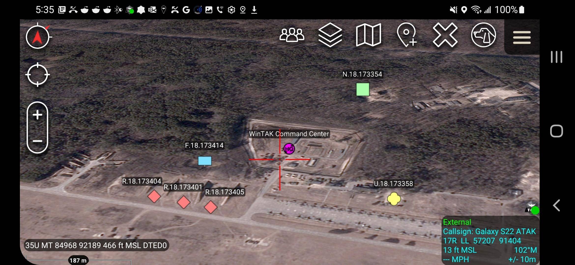
This screenshot from ATAK (Android Team Awareness Kit) shows satellite imagery from BlackSky showing an Airbase in Ukraine. The overlays on the map layer show a WinTAK user connected through the Sit(x) server as well as several points of interest shown with map markers.
“As the name implies, Sit(x) can handle the situational awareness demands of any situation,” said PAR Government President Michael Nelson. “Sit(x) helps front-line commanders and warfighters make faster and better decisions by enabling two-way sharing of vital information. We are thrilled to team up with BlackSky and add their phenomenal space-based image products into the same tactical devices in use by over a quarter million people today.”
“Customers experience a force-multiplying first-to-know advantage with BlackSky’s proprietary high-revisit satellite constellation,” said BlackSky Chief Revenue Officer J.R. Riordan. “Together with PAR Government we’re improving the tactical ISR experience by providing insights and real-time analytics to those serving on the front lines when they need it most.”
Incorporating BlackSky imagery and derived products into Sit(x) is one of the first steps in turning the server into a geospatial data marketplace where users can access a variety of commercial imagery sources as near real-time base maps and other digital data.
At GEOINT 2022 participants can experience how Sit(x) displays the real-time locations of personnel and resources overlaid on a high-resolution multispectral BlackSky satellite image of Ukraine. To participate in the demo, attendees are invited to download the ATAK app and the companion app Sit(x) TeamConnect On-The-Go (OTG) from the Google Play Store, or Sit(x) for iOS from the Apple App Store to their mobile devices where they can view imagery and communicate with other GEOINT attendees.
The Sit(x) demonstrations will occur in Booth 504.
Sit(x) is a commercial Server-as-a-Service solution based on the TAK platform developed by PAR Government for the U.S. Defense & Intelligence Community. Sit(x) establishes real-time communication and information sharing among otherwise non-federated military and civilian personnel during rapidly evolving situations, both planned and unexpected.
With Sit(x), individuals and teams can communicate via standard personal computers and handheld mobile devices by voice, text, or symbology. They can share real-time full-motion video (FMV), GIS layers, airborne/drone imagery, GPS locations, raster maps, photos, and documents and now satellite imagery across their defined group.
PAR developed Sit(x) as an affordable and easy to use cloud-based alternative to TAK Server for organizations. Sit(x) is securely hosted in the AWS Gov Cloud with all hardware/software management handled by PAR. Fully secure and compatible with ATAK, WinTAK, and the just released iTAK, Sit(x) can be accessed via free downloadable gateway applications.
About BlackSky Technology Inc.
BlackSky is a leading provider of real-time geospatial intelligence. Leveraging its own satellite constellation and harnessing the world’s emerging sensor network, the Company monitors the activities and locations worldwide that matter most to its customers. BlackSky’s on-demand constellation of proprietary satellites, together with the sensors in its partners’ constellations, are capable of imaging targeted locations on Earth multiple times a day in a variety of conditions. The data collected from BlackSky’s satellites and other sources populates BlackSky’s proprietary data lake and platform. Cutting-edge computer techniques, including machine learning and artificial intelligence, allow BlackSky’s customers to derive unique and commercially valuable insights, providing them with a first-to-know advantage. BlackSky’s suite of real-time geospatial intelligence products can be integrated into a customer’s system or made available through BlackSky’s Spectra platform using a laptop and internet connection. The Company’s variety of pricing and utilization options enables customers to customize their first-to-know experience. For more information, visit www.blacksky.com.
About PAR Government Systems Corporation
PAR Government Systems is a leader in providing computer-based system design, engineering and technical services to the Department of Defense and various federal agencies. An ISO 9001:2015 and 27001:2013 certified company, PAR Government is a wholly owned subsidiary of PAR Technology Corporation (www.pargovernment.com).
About PAR Technology Corporation
For more than 40 years, PAR’s (NYSE Symbol: PAR) cutting-edge products and services have helped bold and passionate restaurant brands build lasting guest relationships. We are the partner enterprise restaurants rely on when they need to serve amazing moments from open to close, during the most hectic rush hours, and when the world forces them to adapt and overcome. More than 100,000 restaurants in more than 110 countries use PAR’s restaurant hardware, software, drive-thru, and back-office solutions. With the recent acquisition of Punchh Inc., a leading SaaS based customer loyalty and engagement solutions provider, PAR has become a Unified Commerce Cloud Platform for Enterprise Restaurants. To learn more, visit www.partech.com or connect with us on LinkedIn, Twitter, Facebook, and Instagram.
