Following a partnership between Plexscape and Airbus, engineers using AutoCAD can now have easy and fast access to OneAtlas, the Airbus’ geospatial digital platform delivering the freshest satellite imagery, through the new version of Plex-Earth.
By getting access to recent imagery, engineers get a complete understanding of their project sites’ conditions from the very beginning of their design workflow, speeding up processes and avoiding the high cost of rework by reducing errors.
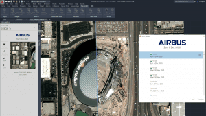
Conventionally, the use of commercial satellite imagery comes with a number of challenges for many businesses, including the requirement for a certain level of technical expertise for importing the data into AutoCAD to get a real-world view of the project areas.
Conversely, free imagery sources are often outdated and unsuitable for commercial engineering use, while ground-based surveys can cost time and money at the expense of the whole project, especially during the initial stages of the concept design process.
Airbus’ frequently-updated imagery also gives a clear picture of how things are changing on the ground over time. This is because Plex-Earth 5 gives users access to Airbus’ massive historical database, which can go back more than 10 years into the past.
Being able to easily detect even the smallest of changes with simple one-click functionality means companies across the spectrum of the AEC industry gain the advantage of powerful and practical insights into both what is really there on site, and what has been happening.
“Both our business model and our direct partnership with Airbus support our core mission which is to open up access to premium data to businesses of any size. The democratization of such data is a core enabler for the transformation of the AEC industry as a whole” said Lambros Kaliakatsos, Plexscape founder and CEO.
The brand new Plex-Earth, launched at this year’s online-only Autodesk University, as a powerful new platform for satellite and aerial imagery,creates a game-changing business model to the global commercial imaging market. Now any business can have easy access to premium current and past geospatial data within AutoCAD, through a variety of affordable Plex-Earth subscriptions.
About Plexscape
Plexscape helps AEC designers have a fast, true understanding of their project sites’ conditions from the very beginning of the design workflow, making sounder decisions, speeding up processes, avoiding mistakes, and reducing rework and overall costs. Our award-winning team (and Autodesk Authorized Developer since 2010) is proud to have created Plex-Earth, the 1st cloud-based platform in the CAD market, loved by thousands of engineers worldwide and one of the most popular plugins in the Autodesk App Store. To see more of what makes Plex-Earth so special visit www.plexearth.com
