(MUNICH, Germany) – Hexagon’s Geosystems division today announced that it has been awarded a contract by the German Federal Agency for Cartography and Geodesy (BKG) to provide a homogeneous, comprehensive digital surface model (DSM) for Germany. The data is provided via the HxGN Content Program, a licensed, high-quality geospatial data service from Hexagon. The program was launched in 2014 and is currently available in Europe and North America.
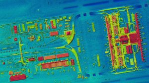
DSM of Munich Airport – With the HxGN Content Program, Hexagon now provides the first up-to-date, homogeneous and high-resolution Digital Surface Model (DSM) of Germany.
The BKG has data sets with general height information of the Earth’s surface across its entire federal territory. However, these can vary from state to state because they are generated from different source data. An up-to-date, homogeneous and high-resolution DSM is required by organizations operating across state borders, such as the Federal Agency for Technical Relief (THW), the German Air Traffic Control, the German Armed Forces Geoinformation Centre and the Federal Office of Civil Protection and Disaster Assistance. The data must meet high quality requirements for positional and vertical accuracy, resolution, currency and flexible licensing options for the federal government, the states, European and international organizations. In addition, the HxGN Content Program offers powerful streaming services.
The DSM is not only of interest to government agencies. The data also offers great value to companies such as telecommunication providers, utilities, transportation networks or insurance companies. Apart from traditional applications, the data is also used in the digital industry to automatically extract features for example with artificial intelligence (AI) or as a base map for the self-driving cars industry. In addition to the DSM, Hexagon also provides aerial imagery (orthophotos) that correlates with the DSM because it is generated from the same data source.
“We are pleased to provide the BKG and the German government agencies with the first high-resolution, homogeneous DSM based on the HxGN Content Program to support sovereign federal tasks,” says John Welter, President Geospatial Content Solutions at Hexagon. “With the HxGN Content Program’s extensive coverage across Europe and North America, we can offer these and additional aerial data products to other countries as well.”
About the HxGN Content Program
Hexagon’s aerial data program, the HxGN Content Program, offers the largest library of aerial imagery and digital surface models across Europe, the United States, and parts of Canada. The data is ortho-rectified, accurate, and available at multiple resolutions. Since its inception in 2014, the program follows rigorous acquisition and processing standards to offer the highest positional accuracy for applications such as mapping, urban planning, asset management, public safety, utility mapping, insurance, app development and many more. The exceptional data consistency over large areas makes this the ideal training data set for machine learning and AI algorithms. For more information, visit hxgncontent.com.
About Hexagon
Hexagon is a global leader in sensor, software and autonomous solutions. We are putting data to work to boost efficiency, productivity, and quality across industrial, manufacturing, infrastructure, safety, and mobility applications.
Our technologies are shaping urban and production ecosystems to become increasingly connected and autonomous – ensuring a scalable, sustainable future.
Hexagon (Nasdaq Stockholm: HEXA B) has approximately 20,000 employees in 50 countries and net sales of approximately 3.9bn EUR. Learn more at hexagon.com and follow us @HexagonAB.
