(Norcross, GA. USA) Innovate UK, the country’s innovation agency, has selected Hexagon’s Geospatial division to conduct a research project that will result in faster and higher-precision mapping of railway infrastructure through the use of artificial intelligence. The project is funded by Network Rail, the owner and operator of Great Britain’s railway infrastructure, under its R&D portfolio and delivered by Innovate UK through the SBRI competition, Innovation in Automated Survey Processing for Railway Structure Gauging, Phase One. A small group of teams was selected for this effort.
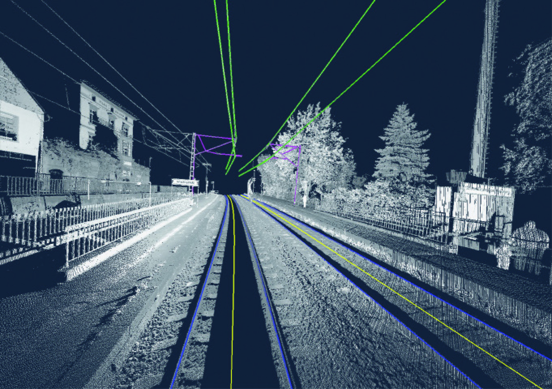
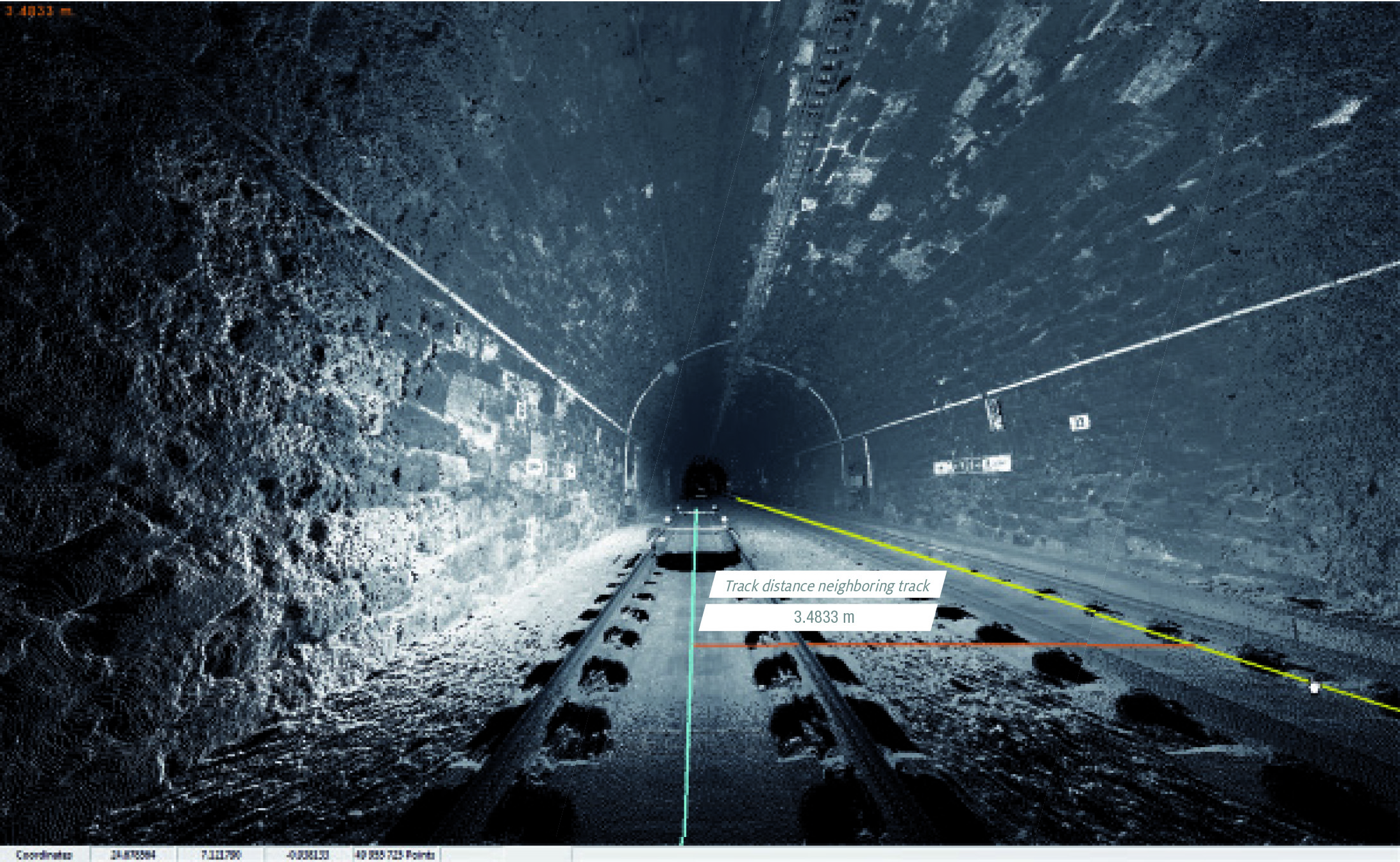
The project will enable Network Rail to automatically identify and measure railway structures from LiDAR data, saving valuable time and resources, while also improving planning and operations across the rail network. The current, manual process takes analysts months or even years due to the size of the data and the labor-intensive tasks involved.
Leica 3D Rail Scan
Leica 3D Rail Scan
“The combination of cross-sectional area, shape, length and speed all place a space requirement on today’s railway,” said James Sweeney, Senior Engineer at Network Rail. “We anticipate this project will offer us a more efficient way to capture, analyse and measure railway features along 20,000 miles of track, which is important to railway safety and the growth and capacity of our network.”
Network Rail collects detailed information about its track and the surrounding features, such as bridges and tunnels. The data is then analyzed to assess clearances between trains and the infrastructure around them, which is key to safety. The new project aims to automate the extraction and calculation of railway features from sensor data, leveraging AI to automatically analyse point cloud data, identify different structure types and perform measurements on the structures. The data will be collected from reality capture solutions from Hexagon’s Geosystems division.
“Network Rail, supported by Innovate UK, is leading the way in the use of AI to automate rail structure identification and measurement,” said Mladen Stojic, president of Hexagon’s Geospatial division. “We are excited to be part of a project that can help transform the gauging process for UK railways.”
Learn more about how Hexagon helps organizations close the gap between the geospatial and operational worlds with its transportation solutions.
Hexagon is a global leader in sensor, software and autonomous solutions. We are putting data to work to boost efficiency, productivity, and quality across industrial, manufacturing, infrastructure, safety, and mobility applications.
Our technologies are shaping urban and production ecosystems to become increasingly connected and autonomous — ensuring a scalable, sustainable future.
Hexagon’s Geospatial division creates solutions that visualize location intelligence, delivering a 5D smart digital reality with insight into what was, what is, what could be, what should be, and ultimately, what will be.
Hexagon (Nasdaq Stockholm: HEXA B) has approximately 20,000 employees in 50 countries and net sales of approximately 4.4bn USD. Learn more at hexagon.com and follow us @HexagonAB.
