Asian Surveying & Mapping
Breaking News
Nuri rocket successfully completes KAIST’s next-gen satellite mission
The Korea Advanced Institute of Science and Technology (KAIST)...
President Lai reviews progress on first indigenous satellite constellation
President Lai Ching-te said developing space technology is a...
Japan’s iQPS lines up eight SAR launches
ST. LOUIS — Japan’s Institute for Q-shu Pioneers of...
UAE Astronauts Promote AI and Collaboration in Space at GITEX Europe
The Arab world’s first astronaut, Hazzaa Al Mansouri, and...
New species of space-adapted bacteria discovered on China’s Tiangong space station
Scientists have discovered a previously unknown strain of microbe...
Isro’s 101st mission fails as PSLV-C61 suffers third-stage anomaly
India’s latest Earth observation satellite mission faced a setback...
Iraq’s First Fully Solar-Powered Village in Kulak Is Now Operational
ERBIL, Kurdistan Region – May 20, 2025 — The...
Australia’s Gilmour Space Technologies ready to launch maiden Eris Test flight the nation’s first orbital launch in over 50 years
Gilmour Space Technologies is the leading launch services company...
Korea’s space agency seeks revision of plan to modify next-gen rockets into reusable system
South Korea's aerospace agency said on Thursday that it...
UAE Space Agency Signs Agreement With Technology Innovation Institute to Execute the Emirates Mission to the Asteroid Belt’s Lander Project
In the presence of His Highness Sheikh Hamdan bin...

July 14th, 2020
Dewberry to Provide Enhanced QL1 Lidar for Florida Panhandle

Firm to provide data for U.S. Geological Survey following widespread impacts of Hurricane Michael.

Dewberry, a privately held professional services firm, announced that it has been selected by the U.S. Geological Survey (USGS) to provide updated base elevation models for the panhandle region of Florida, which was heavily impacted by Hurricane Michael in 2018.

The firm has collected data for approximately 8,000 square miles of Florida, including the counties of Washington, Bay, Jackson, Calhoun, Gulf, Gadsden, Liberty, Franklin, Leon, Wakulla, and portions of Walton, Holmes and Jefferson. The data will be processed to quality level 1 (QL1) specification requirements, which is >8 points per square meter, with roughly 5,700 square miles at the Florida enhanced hydrography QL1 specification requirements and the remaining 2,550 square miles at the USGS National Geospatial Program Lidar Base Specification version 2.1.

“We are thrilled to help USGS, partner federal agencies, and the state of Florida work toward achieving their goal of procuring statewide QL1 Lidar coverage with enhanced hydrographic specifications for storm surge modeling,” says Dewberry Project Manager Emily Klipp. “With these data, federal and state officials and safety experts will be better informed when determining climate adaptation strategies.”
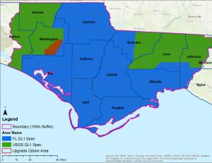
This project provides high-density lidar for more than 8,000 square miles of the Florida Panhandle with roughly 5,700 square miles of enhanced hydrographic specifications for storm surge modeling. Photo courtesy of Dewberry.