Asian Surveying & Mapping
Breaking News
Australian Space Agency funds development of aerospace-grade GNSS receiver
The Australian Space Agency has funded the development of...
Continuity risks for Australian EO data access
A new report details the widespread use of Earth...
China launches new remote sensing satellite
JIUQUAN, April 15 (Xinhua) -- China on Monday launched...
7.4-Magnitude Earthquake Strikes Taiwan
A major, 7.4-magnitude earthquake struck the eastern coast of...
Tata Deploys Its Geospatial Satellite In Space on Space X’s Falcon 9 Rocket
THIRUVANANTHAPURAM: Tata Company launched India's first private commercial satellite...
Taiwan’s Formosat-8 Satellite Set for Launch by 2025
The Taiwan Space Agency has announced progress on the...
Iranian Scientists to Build Satellite Constellation for 2 Simultaneous Missions
The scientists at the knowledge-based company had previously succeeded...
China provides geospatial intel and other military support to Russia, US says
The US has warned its European allies that China...
Japanese lunar lander company ispace raises $53.5 million in stock sale
WASHINGTON — Japanese lunar lander developer has raised $53.5...
Esri and Prince Sultan University Advance GIS Education Through Strategic Partnership
Memorandum of Understanding with Institution Enhances GIS Curriculum and...

March 5th, 2020
TURKEY / GREECE BORDER: Satellite Images Show Refugee Crisis

Thousands of refugees wait patiently in line at the Turkey border, as they await passage into Greece.

Satellite images captured only hours ago with WorldView-3 by European Space Imaging, show long lines of refugees on the road, numerous buses and trucks, as well as temporary housing facilities scattered adjacent to the road, extending well into the nearby forest.
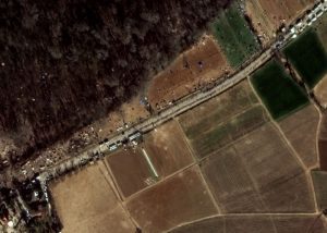
Several buses on the road towards the border are clearly identifiable, correlating with reports that refugees are being bused to the area. In addition, numerous smaller vehicles with crowds of people surrounding can be seen. This could be indicative of aid support in the area. For security and safety, the border is being closely monitored by Frontex to mitigate any crises that could arise. “We are looking at other ways to help EU countries that border Turkey,” the agency said.

“Very High Resolution satellite imagery is both a cost-effective and time-efficient method of monitoring European borders as it allows identification of small objects in near real-time,” said Adrian Zevenbergen, Managing Director, European Space Imaging. “Country borders can run across long distances of differing terrain and people are small. Monitoring these areas frequently enables us to track refugee movements in order to ensure their safety.”

European Space Imaging will continue to monitor this situation and make images available as soon as possible.