Vaughan, Ontario — Teledyne Optech, a Teledyne Technologies [NYSE:TDY] company and global leader in lidar sensing, is pleased to announce that OGL Engineering of Calgary, Alberta is the first Canadian company to purchase the Optech Galaxy T2000 lidar sensor. With the purchase of the Galaxy T2000 and a GSM4000 sensor mount, OGL will increase the efficiency of their aerial data collection, which includes projects for a variety of industries including: electric utilities, pipelines, forestry, mining, and government infrastructure. As a team that provides A to Z aerial survey services from project design and data acquisition, through to data processing and engineering analysis, OGL understands how integral a reliable and efficient data acquisition solution is to achieve project success.
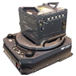
The Galaxy T2000 boasts a true 2 MHz laser emission rate directed fully to the ground by a new high frequency, programmable scanner for effective point distribution. Combined with Teledyne Optech’s patented SwathTRAK™ capability, the Galaxy T2000 is capable of maintaining fixed-width data swaths in mountainous terrain via an innovative and dynamic field-of-view (FOV), enabling far fewer flight lines and more equidistant point spacing compared to fixed-FOV sensor designs.
“We are pleased that OGL Engineering has chosen the T2000 as a replacement for their current lidar sensor,” said Optech Executive Vice President and General Manager, Michel Stanier. “The T2000 is the highest performance sensor in the market with a true 2 MHz laser PRF featuring SwathTRAK and PulseTRAK technologies.”
“OGL is excited to start off the 2020 season, which is also our 40th anniversary, with the new Teledyne Optech T2000 sensor,” said OGL CEO, Tammy Smith. “OGL prides itself on providing the best-available custom solutions for our clients, and the versatility of the new T2000 will allow us to efficiently collect high density, high-accuracy and high-quality lidar data for project areas ranging from a narrow utility corridor to wide area forestry projects. This is especially true for projects in the variable terrain of our backyard, the Rocky Mountains, thanks to the built-in SwathTRAK technology. With the addition of the T2000 to our sensor complement, we are ensuring our clients will have access to leading edge technology and high-quality data on which to base their critical decisions.”
Find out more at www.teledyneoptech.com.
About Teledyne Optech
Teledyne Optech, part of Teledyne Imaging Group, is a world leader in high-accuracy lidar 3D survey systems, integrated cameras, and productivity-enhancing workflows. With operations and staff worldwide, Teledyne Optech offers both standalone and fully integrated lidar and camera solutions for airborne mapping, airborne lidar bathymetry, mobile mapping, terrestrial laser scanning, and mine cavity monitoring, as well as space-proven sensors. Teledyne Optech supports its clients with an around-the-clock team, on-site service, and regular efficiency enhancements to the workflow of its integrated systems. Accuracy and productivity matter!
Teledyne Imaging is a group of leading-edge companies aligned under the Teledyne umbrella. Teledyne Imaging forms an unrivalled collective of expertise across the spectrum with decades of experience. Individually, each company offers best-in-class solutions. Together, they combine and leverage each other’s strengths to provide the deepest, widest imaging and related technology portfolio in the world. From aerospace through industrial inspection, radiography and radiotherapy, geospatial surveying, and advanced MEMS and semiconductor solutions, Teledyne Imaging offers world-wide customer support and the technical expertise to handle the toughest tasks. Their tools, technologies, and vision solutions are built to deliver to their customers a unique and competitive advantage.
About OGL Engineering
Founded in 1980 as The ORTHOSHOP, OGL Engineering is a leading provider of geomatics engineering services based in Calgary, Alberta. OGL provides professional geomatics solutions to clients in an engaged and collaborative environment, with full in-house execution capabilities including geomatics engineering consulting, remote sensing data acquisition, data processing and analysis. OGL specializes in projects where accuracy and execution speed are critical.
