DENVER, Colorado, USA – LAND INFO Worldwide Mapping LLC, the premier provider of mapping solutions for 5G wireless in North America, has assembled a world-class team of geospatial companies to extend its reach in the 5G industry in Europe. The LAND INFO team includes Bluesky International Ltd. in the U.K. and COWI (soon to be part of Hexagon Group) in continental Europe.
“Our international team will give 5G wireless operators in Europe direct local access to the geospatial data and expertise they need to develop state-of-the-art telecommunications networks,” said LAND INFO president Nick Hubing.
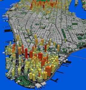
LAND INFO uses the most detailed aerial sources to create precise mapping optimized for demanding 5G network planning and design. This Manhattan, New York, 3D data set includes 3D building structures with detailed segmenting and contoured treed vectors with understory modeling.
LAND INFO timed the announcement with this week’s Hexagon Geospatial Content User Group Meeting in Seville, Spain, where Hubing will present “Mapping for Wireless Telco: From Landsat to CityMapper” on Friday, Feb. 21, at 10 am.
Based in Ashby-De-La-Zouch, England, Bluesky is an innovative aerial survey company with offices in Great Britain, Ireland, and the U.S. COWI is an international engineering consultancy based in Denmark with more than 400 aerial mapping personnel in offices across Europe and India. COWI’s aerial mapping business will join Hexagon in Q2 2020.
LAND INFO entered into the collaboration with Bluesky and COWI based on their acknowledged leadership in aerial data acquisition and well-established sales networks across the United Kingdom and Europe. Both organizations are constantly adding updated data to their geospatial archives, capturing in stunning 3D detail the rapid changes occurring across Europe.
“Years of experience have demonstrated that aerial data delivers the detail and accuracy required for optimal 5G network engineering,” said Hubing. “We have used Hexagon aerial imagery at scale in North America for several years, and our technology is optimized to work with Hexagon’s Leica aerial sensors, including the new CityMapper.”
LAND INFO emerged as a primary provider of 5G network mapping solutions after making significant investments in developing automated geospatial technologies that include object-based image analysis and artificial intelligence. These proprietary technological advancements have uniquely positioned LAND INFO to meet the demanding mapping specifications of 5G network design worldwide.
LAND INFO differentiates itself from other mapping firms by using these proprietary techniques to quickly extract scalable elevation and landcover information from very high-resolution aerial imagery. The signal propagation characteristics of 5G cell design require a level of detail and accuracy that is best met with airborne-derived data.
Representatives from LAND INFO will be discussing geospatial solutions for 5G network design at Mobile World Congress in Barcelona, Spain (when rescheduled). Future 2020 trade show exhibitions include the BIG 5G Event being held May 18-20 in Dallas, Texas, and 5G World in London on June 9-11.
For more information on Bluesky, visit www.bluesky-world.com. Details on COWI may be found at www.cowi.com.
About LAND INFO
Founded in 1993, LAND INFO is unique for using both aerial and satellite remote sensing to custom create geodata solutions optimized for specific vertical market applications worldwide, including oil and gas, electric utilities, government, visualization/simulation, NGOs, academia, and autonomous vehicle navigation. The company’s significant investments in automated mapping technologies, including Object Based Image Analysis and Artificial Intelligence, allow it to offer competitive pricing, fast turnaround time and industry-leading quality to support large projects. Visit www.landinfo.com for more information.
