
Vaughan, Ontario, January 21, 2020 — Teledyne Optech, a Teledyne Technologies [NYSE:TDY] company and global leader in lidar sensing, is pleased to announce that Atlantic is first to take possession of the new Optech G2 sensor system, which will accommodate their two Optech Galaxy Prime airborne lidar sensors. Atlantic will also take delivery of three Optech Galaxy T2000 lidar sensors by the end of Q1. The G2/T2000 upgrade purchase will bolster Atlantic’s single-swath pulse density and operational efficiency for forestry, rail, electrical utilities, and other high-density applications.
The Galaxy T2000 features a true 2-MHz laser PRF, even greater range performance and further improved scan efficiency. The customizable G2 sensor system incorporates two Prime or T2000 sensors and is configured for adjustable fore and aft pitch to provide optimum vertical surface resolution and ground point density in forestry, corridor and urban projects. Using two T2000 sensors on the G2 will enable Atlantic to survey at a full 4 MHz on the ground and achieve staggering point densities to rival flash lidar capabilities.
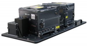
“We are thrilled to partner with Atlantic to deploy not only the T2000, our 4th generation Galaxy and another major leap forward in airborne survey productivity and accuracy, but also the revolutionary G2 dual-sensor system which provides the best that an airborne lidar system can offer, and now at unrivalled point densities thanks to its true 4-MHz laser PRF,” said Optech Executive Vice President and General Manager Michel Stanier.
“Atlantic and our clients have benefited from our initial investment in three Optech Galaxy Primes,” said Brian Mayfield, President and CEO of Atlantic. “Teledyne Optech’s revolutionary technologies of SwathTRAK™ and PulseTRAK™ are truly game changers – especially in variable terrain. We have so much faith in the additional advancements in the laser head coming from Optech’s engineers, we have pre-purchased the T2000 upgrade for all three of our sensors. Combined with the G2 dual sled that we also purchased, the T2000 in dual configuration will allow us to utilize proven lidar technology to achieve similar pulse densities to less-proven, emerging lidar sensors that have been commonly discussed in recent years.”
Find out more at www.teledyneoptech.com.
About Teledyne Optech
Teledyne Optech, part of Teledyne Imaging Group, is a world leader in high-accuracy lidar 3D survey systems, integrated cameras, and productivity-enhancing workflows. With operations and staff worldwide, Teledyne Optech offers both standalone and fully integrated lidar and camera solutions for airborne mapping, airborne lidar bathymetry, mobile mapping, terrestrial laser scanning, and mine cavity monitoring, as well as space-proven sensors. Teledyne Optech supports its clients with an around-the-clock team, on-site service, and regular efficiency enhancements to the workflow of its integrated systems. Accuracy and productivity matter!
Teledyne Imaging is a group of leading-edge companies aligned under the Teledyne umbrella. Teledyne Imaging forms an unrivalled collective of expertise across the spectrum with decades of experience. Individually, each company offers best-in-class solutions. Together, they combine and leverage each other’s strengths to provide the deepest, widest imaging and related technology portfolio in the world. From aerospace through industrial inspection, radiography and radiotherapy, geospatial surveying, and advanced MEMS and semiconductor solutions, Teledyne Imaging offers world-wide customer support and the technical expertise to handle the toughest tasks. Their tools, technologies, and vision solutions are built to deliver to their customers a unique and competitive advantage.
