
PHOENIX – AerialSphere, an innovative tech startup creating immersive and interactive 360-degree maps, is offering real estate agents the opportunity to add what some consumers are calling an “addictive” online experience to their websites. Partnering with iFoundAgent, an award-winning marketing service and website provider, AerialSphere is transforming the way Phoenix home buyers shop for a home online.
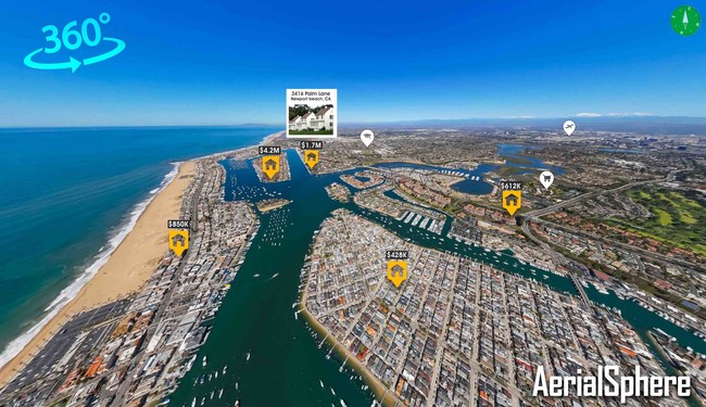
“The world is not flat, so why should the maps we use every day be?” said AerialSphere co-founder and resident DJ Vegh. “AerialSphere-powered maps, unlike Google Maps, provide a 3D-type experience that allows you to see the world the way we should see it — as if you are there.”
Because 90 percent of all consumers begin their real estate search online, iFoundAgent was quick to adopt a new technology “that right now, none of our competitors offer,” according to Dave Mason, iFoundAgent founder and owner.
Mason says AerialSphere’s mapping technology, which iFoundAgent dubbed “The World’s First 3D Home Search,” creates an online home search experience that is transformational.
“When I heard about it, I thought it was just like Google Maps, so who cares?” Mason said. “But when I first saw it, I actually got a chill up my spine — this was something new. It was kind of like when I saw the first iPhone; I knew it was going to change everything.”
For top-producing Phoenix-area agent Sean Hahn, AerialSphere 360-degree immersive and interactive maps have quickly become a crucial sales tool. The maps are a central component of his iFoundAgent provided marketing platform.
Hahn is with West USA Realty, one of the largest real estate firms in Arizona, with some 2,000 agents and 18 office locations. He leverages the new mapping technology throughout his communications with clients and potential clients. Hahn incorporates links to his 3D maps in automated personalized email offers to new clients for free marketing analysis. For existing clients, he provides links to a map showing the final price on recent neighborhood home sales.
“The first thing that pops up is this giant 3D map showing homes and an indicator showing the final sales price,” Hahn explained. “These maps are interactive and allow you to fly through neighborhoods in a way that feels like you are there. You can see the topography. It’s not flat like all other maps.
“In Phoenix, we live in a valley with mountain ranges surrounding us. We also are a very active community. People hike our mountains or want to ride a horse or a bike through them. These maps are the most powerful way to figure out where a house is in relationship to all of our outdoor activities, from mountains to parks to schools. It’s simply the coolest thing ever,” Hahn said.
DJ Vegh co-founder, President at AerialSphere notes his mapping technology appeals not just to residential real estate, but has significant applications for commercial real estate. He said CB Commercial Real Estate is also piloting its maps and using its API (application program interface).
Vegh explained that AerialSphere’s unique mapping technology has business application opportunities for industries that collectively contribute more than one-third of the U.S. annual GDP (gross domestic product).
“AerialSphere serves the four largest drivers of the U.S. economy: real estate, state and local governments, insurance, and travel industries,” Vegh said.
Real estate (including renting and leasing) is the largest sector of the U.S. economy, accounting for 13% of our national GDP ($1.898 trillion). The housing sector employs more than 1.9 million people. State and local governments rank second and represent 9% of U.S. national GDP ($1.336 trillion) and employ 7.4 million people. Finance and insurance account for 8% of U.S. national GDP ($1.136 trillion). The insurance industry alone employs 2.69 million people. And travel represents 7.8% of our national GDP ($1.1 trillion). The U.S. travel industry employs 5.29 million people.
AerialSphere uses a patented four-step process. This patented process includes the rapid capture of immersive aerial maps, the ability to integrate latitude and longitude to match each image pixel, connect location-based API data to its immersive map viewer, and provide detailed user interaction tracking.
AerialSphere is mapping the U.S., rapidly capturing a massive array of 360-degree immersive, aerial, spherical images over large urban areas. Able to cover an average of 120 square miles per hour, AerialSphere can cover an average-sized U.S. metropolitan area in a few hours.
More information about AerialSphere can be found on its website, AerialSphere.com, as well as at iFoundAgent’s website, ifoundagent.com. An AerialSphere video demo is available at https://vimeo.com/144810677.
About AerialSphere
AerialSphere is changing how the world views maps. Its multi-patented technology mass captures immersive 360-degree aerial photos and then matches each pixel to its longitude and latitude coordinates. AerialSphere enables an immersive, 3D-type experience that is transforming real estate and travel search while powering applications for the insurance industry and governments. Backed by private equity firm Jokake Companies, AerialSphere mapping brings a true perspective to every location, from viewing homes for sale or street addresses to show the most accurate proximity of schools, parks, churches, or other points of interest. Learn more at AerialSphere.com.
