DENVER, Colorado, USA – The Denver Business Journal has named LAND INFO Worldwide Mapping LLC one of fastest growing private companies in the Denver area. LAND INFO achieved 226% growth from 2016 to 2018 to make the 2019 Denver Fast 50 list.
“The Denver area is an international hub of geospatial activity with a high concentration of companies representing every sector of the industry,” said LAND INFO president Nick Hubing. “LAND INFO is honored to be the top-ranked geospatial firm on this year’s Fast 50 list.”
Hubing credits the rapid growth to an increased demand from the 5G wireless market and the company’s ability to provide customized mapping services for a variety of applications. Since 1993, LAND INFO has generated map data sets from remotely sensed imagery for the oil & gas, electric utilities, telecommunications, government, visualization/simulation, NGOs, academic and autonomous vehicle markets.
“The expertise of our personnel combined with our investments in object-based image analysis and artificial intelligence enables us to meet diverse mapping needs,” said Hubing. “We have the agility to create custom solutions for specific industries, as well as for individual clients within those sectors.”
The global telecommunications market is an example where the 5G wireless network designers have exacting geospatial data needs that are rapidly evolving. LAND INFO differentiates itself in the sector by using proprietary techniques to quickly extract scalable elevation and landcover information from very high-resolution aerial imagery for 5G cell design which requires a level of detail and accuracy— especially vertical obstacle height data – that is best met with airborne data.
According to Hubing, LAND INFO’s personnel are its greatest resource in delivering such a wide variety of custom geospatial solutions. The firm’s employees average 22 years in the geospatial industry, many of them having worked for some of the largest and best-known providers of satellite and airborne image data worldwide.
“Through our partnerships with the world’s premier aerial and satellite operators, we are able to source the most effective geodata,” said Hubing. “The LAND INFO team then applies their unsurpassed skills, knowledge and expertise to create the optimized mapping solutions with value-added processing our clients require.”
The full Denver Fast 50 report is behind a paywall, but the LAND INFO profile may be found at this link.
In August, LAND INFO was honored by Inc. Magazine and named among the fastest-growing private companies in the United States. Details may be found at www.inc.com/inc5000.
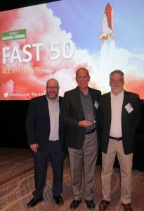
LAND INFO executives accept Denver Fast 50 Award at reception hosted by Denver Business Journal – (L to R) Chris Lowe, Director Image Analysis; Nick Hubing, President; David Steveley, Director Business Development.
About LAND INFO
Founded in 1993, LAND INFO is unique for using both aerial and satellite remote sensing to custom create geodata solutions optimized for specific vertical market applications. The company’s significant investments in automated mapping technologies, including Object Based Image Analysis and Artificial Intelligence, allow it to offer competitive pricing, fast turn-around time and industry-leading quality to support large projects. For more information on LAND INFO, visit www.landinfo.com. If you would like to search for imagery available for your area of interest, click on http://search.landinfo.com/.
