(HEERBRUGG, Switzerland, STUTTGART, Germany) – Leica Geosystems, part of Hexagon, is pleased to announce the Carl Pulfrich Award 2019 was awarded to Prof. Dr. Bisheng Yang for outstanding contribution in the field of point cloud processing. The Carl Pulfrich Award is a prestigious award for honouring cutting-edge innovations and developments in geodesy, photogrammetry and the Earth sciences.
“I’m deeply pleased to receive this recognition of my work among so many notable participants. It is a confirmation of my efforts, and I sincerely thank the jury members for selecting my nomination and honouring me with this award,” said Dr. Yang.
Receiving a considerable number of highly-qualified nominations, Dr. Yang was selected by the 10-member jury and awarded the Carl Pulfrich Award 2019. Dr. Yang is a full professor in GeoInformatics at Wuhan University, China, Head of Division of Integration of GPS, GIS and Remote Sensing. He obtained his Ph.D in Photogrammetry and Remote Sensing in 2002 from Wuhan University. His research expertise includes mobile mapping, UAV mapping, point cloud processing, and GIS applications. Dr. Yang has so far published more than 100 papers in peer-reviewed journals, conferences and workshop proceedings. He is co-chair of Point Cloud Processing Workgroup in Photogrammetry Commission of the International Society for Photogrammetry and Remote Sensing (ISPRS) from 2016-2020 and Editorial Boarding Member of ISPRS Journal of Photogrammetry and Remote Sensing from 2016-2020.
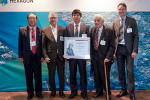
From left to right: Dr. Deren Li, Professor Wuhan University, Member of the Chinese Academy of Science; Dr. Hartmut Rosengarten, Director Airborne Solutions EMEA, Leica Geosystems; Prof. Dr. Bisheng Yang, Professor Wuhan University; Prof. Dr. mult. Fritz Ackermann, Emeritus Institute for Photogrammetry, University of Stuttgart; Prof. Dr.-Ing. Uwe Sörgel, Institute for Photogrammetry, University of Stuttgart.
The chair of the 2019 jury, Prof. Dr.-Ing. Uwe Sörgel, added, “I would like to congratulate Prof. Dr. Bisheng Yang on receiving this significant award and thank him for his hard work, dedication and commitment to the geospatial industry.”
The tribute was given by Dr. Hartmut Rosengarten, director Airborne Solutions EMEA of Leica Geosystems, at the Carl Pulfrich Award Ceremony 2019 during the 57th Photogrammetric Week at the University of Stuttgart.
The academic Earth imaging community was encouraged to submit nominations for the biennial award. Nominees were considered on the basis of experience, activities in fields of photogrammetry, and remote sensing, and contributions to the advancement of all aspects of the Earth imaging field. Applied work involving hardware systems, software solutions or innovative service activities were considered as well.
About the Carl Pulfrich Award
The Carl Pulfrich Award is a prestigious award for recognising cutting-edge innovations, hardware and software developments and integrated systems design in geodesy, photogrammetry and the Earth sciences. Launched in 1968, it is announced biennially and attracts nowadays nominations and recommendations for candidates from all over the world. The biennial award honours the memory of Dr. Carl Pulfrich, a member of the scientific staff at Carl Zeiss from 1890 to 1927. During his tenure, Pulfrich directed the design of the first stereo photogrammetric and surveying instruments from Zeiss. Originally launched by Carl Zeiss, Oberkochen, then re-launched by Z/I Imaging and Intergraph, it was adopted by Leica Geosystems’ Geospatial Solutions Division in 2011. For more than four decades, the Carl Pulfrich Award has recognised the many contributions of scientists worldwide.
Leica Geosystems – when it has to be right
Revolutionising the world of measurement and survey for nearly 200 years, Leica Geosystems, part of Hexagon, creates complete solutions for professionals across the planet. Known for premium products and innovative solution development, professionals in a diverse mix of industries, such as aerospace and defence, safety and security, construction, and manufacturing, trust Leica Geosystems for all their geospatial needs. With precise and accurate instruments, sophisticated software, and trusted services, Leica Geosystems delivers value every day to those shaping the future of our world.
Hexagon is a global leader in sensor, software and autonomous solutions. We are putting data to work to boost efficiency, productivity, and quality across industrial, manufacturing, infrastructure, safety, and mobility applications.
Our technologies are shaping urban and production ecosystems to become increasingly connected and autonomous — ensuring a scalable, sustainable future.
Hexagon (Nasdaq Stockholm: HEXA B) has approximately 20,000 employees in 50 countries and net sales of approximately 3.8bn EUR. Learn more at hexagon.com and follow us @HexagonAB.
Hexagon is a global leader in digital solutions that create Autonomous Connected Ecosystems (ACE). Hexagon (Nasdaq Stockholm: HEXA B) has approximately 20,000 employees in 50 countries and net sales of approximately 3.8bn EUR.
