Accra/Edinburgh – Ghana is stepping up its commitment to help end deforestation due to cocoa farming, by partnering with Ecometrica, the downstream space and sustainability company. The agreement sees the Forestry Commission of Ghana (FCG) adopt the Ecometrica mapping platform in its production and delivery of high quality maps and forest monitoring information, which are at the heart of the Cocoa & Forests Initiative Frameworks for Action (CFI), agreed by Ghana and Côte d’Ivoire at the COP23 UN Climate Change Conference.
Kwadwo Owusu Afriyie, chief executive of FCG, stated that the accurate and timely information, accessible to all stakeholders, are critical to the future success of the CFI, sustainable forest management and reliable information for international forest monitoring obligations in Ghana.
“The Ecometrica Platform will provide access to essential mapping and monitoring information to cocoa industry, stakeholders and national institutions involved in the CFI, to ensure compliance with legal and voluntary commitments.”
As leader of the UK Space Agency’s Forests 2020 Project, Ecometrica has been supporting the FCG improve its monitoring and mapping to determine the effects of cocoa farming on forests for several years. This new agreement ensures that the collaboration will continue beyond the life of the project funding.
Ecometrica’s executive chairman, Dr Richard Tipper, explained: “This is a landmark step in our plans for Ghana and an important development in ensuring sustainability beyond 2020.
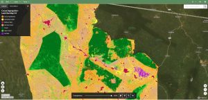
Screenshot from the Ecometrica platform showing new cocoa landscape land classification map produced by the Ghana Forestry Commission
“Significantly, this will also create a long-term revenue stream for the Commission, as we will also distribute the maps that have been created by the Commission. This will help make its commitment to high quality mapping and monitoring of cocoa farms and forests self-sustaining.”
Sarah Middlemiss, space programme manager at Ecometrica, who has led the Forests 2020 project for the company, said accurate and readily available maps would be essential to ensure the success of the initiative.
“This agreement ensures the tools and methods developed through Forests 2020 will be widely adopted and become the national standard in Ghana,” Middlemiss said. “For the companies involved, that gives them the security of monitoring their supply chains through a state-of-the-art system that is guaranteed by a national government.”
Cocoa buyers need to be able to accurately assess the impact of their efforts to combat deforestation in their supply chains, and this agreement will provide commercial access to accurate and regularly updated maps.
Because cocoa is a shade-loving crop and can grow under forest canopy, other available methods to map the spread of cocoa farming had proven ineffective. The work carried out by Ecometrica and its partners in Ghana, through the Forests 2020 project, ensured that accurate maps were developed, showing the true impact of the cocoa supply chain. These will now be updated on a regular basis to reflect efforts to tackle deforestation.
Further agreements between Ecometrica and the companies involved in the Cocoa and Forests Initiative are expected, as the company’s technology and content platform helps create a new standard for environmental monitoring.
Forests 2020 is a major investment by the UK Space Agency, as part of the International Partnerships Programme (IPP), to help protect and restore up to 300 million hectares of tropical forests by improving forest monitoring in six partner countries through advanced uses of satellite data. IPP is a £30m a year programme funded from the UK government’s Global Challenges Research Fund (GCRF). IPP uses satellite data to deliver measurable impact to developing and emerging economies, directly influencing 10 UN Sustainable Development Goals. Forest2020 is the largest project within IPP’s portfolio.
Project managed by Ecometrica, Forests 2020 brings together some of the UK’s leading experts on forest monitoring at the Universities of Edinburgh and Leicester, and Carbomap.
