Asian Surveying & Mapping
Breaking News
Launch of Australia’s 1st orbital rocket, Gilmour Space’s Eris-1, delayed again
Update for 6:15 p.m. ET on July 1: Gilmour Space...
SAASST, UAE Space Agency strengthen scientific partnership
SHARJAH- Prof. Hamid M.K. Al Naimiy, Director of the...
Shubhanshu Shukla to speak to students and ISRO scientists this Friday
Indian astronaut Shubhanshu Shukla will interact with school students...
ISRO hands over 10 advanced technologies to Indian firms in major push for space commercialisation
The Indian Space Research Organisation (ISRO) has transferred ten...
DIGIPIN Launched: India Embraces Geospatial Precision in Digital Addressing
IIT Hyderabad (IITH), in partnership with the Department of...
HAL to build, market Isro’s SSLV in landmark deal
New Delhi, Jun 20: In a historic move for...
Taiwan developing space capabilities for all-weather imaging
TAIPEI (TVBS News) — Taiwan is advancing its space...
Honda hails successful test of reusable rocket as it looks to get into the space business
Tokyo — Japan's second-biggest carmaker, Honda, has successfully tested...
China’s space program provides larger platform for broader international cooperation
BEIJING -- Experts from China's manned space program said...
India To Launch $1.5 Billion Joint Earth Mission With NASA In July
National Aeronautics and Space Administration (NASA) and the Indian...

April 26th, 2018
Four Ways Maptitude 2018 Saves You Time & Money

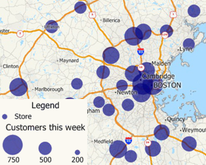
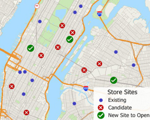
NEWTON MA (USA) – Business analysts need their latest data in their maps. Franchisors and retailers need to ensure that their store network is optimized to best serve their customer base. Hospitals and banks need the most up-to-date demographic information. Maptitude 2018 makes it easier than ever to meet these requirements. Here are 4 key areas where Maptitude 2018 will prove critical for your organization:

  1. Data Linking and Updating: Maptitude can link to external data such as an Excel spreadsheet or SQL Server database and can update your map layers based on changes in your tables without having to reimport your data from scratch. .
  2. Logistics: The Distance and Travel Time Tables Tool creates an Excel table that lists the cost of travel between any number of origins and destinations. You can quickly identify the closest and backup locations ranked by straight line distance, travel distance, or travel time.
  3. Site Selection: The Facility Location Wizard identifies good locations for warehouses, hospitals, retail stores, manufacturing plants, and other types of facilities. The goal in locating such facilities is to provide a high level of service.
  4. Software and Data: Many MapPoint users have switched to Maptitude, but there is still widespread use of MapPoint. Using MapPoint is detrimental to your business operations and destroys the credibility of your reports because the data you are using was outdated even at the time of release. Maptitude 2018 ships with the most up-to-date geographic and demographic information available. Maptitude also includes all the key features and tools of MapPoint.

There are many more improvements in Maptitude 2018! Please contact the Maptitude Sales Team with any questions.

One-step updating from your data source
Distance tables among points or areas
Maptitude facility location wizard
Maptitude 2018 includes the most up-to-date data

About Caliper

Caliper Corporation develops state-of-the-art Geographic Information Systems (GIS) software. With a focus on usability, Maptitude is designed to be a cost-effective, professional mapping software product. Maptitude enables organizations to leverage their location-based data to improve decision making and planning, while minimizing expenditure through competitively priced solutions.

Caliper is a privately held corporation and is a leading developer of mapping, redistricting, transportation, and GIS software.