Asian Surveying & Mapping
Breaking News
Isro’s Bahubali LVM3 that launched Chandrayaan-3 to be handed to private sector
IN-SPACe has invited Indian companies to take over the...
India to host 13th UN Global Geospatial Information Management Asia-Pacific Conference
India is hosting the 13th United Nations Global Geospatial...
Unseenlabs’ BRO-22 to Become the First Foreign Private Satellite Launched Aboard Japan’s H3 Launch Vehicle
Scheduled for June 10, between 09:53 and 11:52 a.m....
PLD Space increases investment in its Launch Complex at the Guiana Space Centre (CSG) to €35M, strengthening Europe’s sovereign space infrastructure
The investment is expected to generate approximately €21 million...
India seeks Singapore capital to fuel its ambitious private space sector
India aims to grow its space economy to US$44...
China conducts surprise launch of Long March 12B, delivers Qianfan satellites on debut flight
HELSINKI — China conducted the maiden launch of its...
ISRO to launch first unmanned Gaganyaan mission by year’s end
The Chairman of ISRO, Somnath said that the efforts...
ORF- RSIS Special Report Launch | India and Southeast Asia: Mapping Strategic Convergence in an Era of Great-Power Competition
In 2014, Prime Minister Narendra Modi announced India’s shift...
Israel defense ecosystem meets to accelerate fieldable counter‑drone tech
Sparked by a message from the frontlines, CET Sandbox...
Chinese startup Mega Engine advances reusable staged-combustion rocket engine
HELSINKI — A new Chinese commercial rocket engine startup...

April 17th, 2026
EarthCARE Captures Eye of Typhoon Sinlaku 

The EarthCARE satellite (Japanese name: Hakuryu) successfully passed directly over the eye of Typhoon Sinlaku on April 13, 2026, capturing unprecedented observations of the typhoon’s internal cloud structure. This rare overpass enabled detailed measurements of the vertical dynamics within the storm’s clouds. 

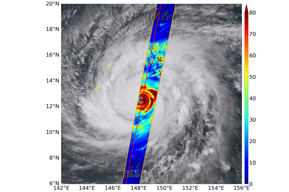
The accompanying image shows a cloud distribution of Typhoon Sinlaku observed by EarthCARE’s MultiSpectral Imager (MSI). The red line indicates the flight path of EarthCARE, and the orange line shows the swath of MSI observation. The color scale represents cloud optical thickness estimated from MSI data. The background image is an RGB composite from Himawari9. 

Image Credit: JAXA