Asian Surveying & Mapping
Breaking News
Japan Eyes Sovereign D2D Satellite Network
Japan plans to select a proposal this month for...
China schedules Long March 10B rocket launch and recovery attempt
HELSINKI — China is set for a debut flight...
BRICS space agencies meet begins in Bengaluru
Heads and senior representatives of the space agencies of...
“India’s growing space ecosystem to drive global collaboration”, says ISRO Chairman V Narayanan after BRICS Space Agencies Meeting
"India's growing space ecosystem to drive global collaboration", says...
UAE aims to see Emirati on Moon in next 10 years, says MBRSC chief
UAE expects to have a presence on the Moon within...
Safran, SatSure partner to develop geospatial intelligence solutions for India
French aerospace giant Safran Electronics & Defense and Indian...
Singapore unveils road map to help develop international business standards and conformance
Singapore has unveiled plans to help develop international standards...
Adelaide University to run space and defence venture launchpad ahead of Australian Space Forum
Adelaide University’s Innovation & Collaboration Centre (ICC) will deliver...
Japan’s H3 rocket returns to space with successful launch after December setback
Japan’s flagship H3 rocket has returned to flight six...
KONGSBERG accelerates seabed mapping developments with Ocean Exploration Trust expedition aboard Exploration Vessel Nautilus
KONGSBERG and the Ocean Exploration Trust (OET) are set...

March 24th, 2026
Tropical Cyclone Narelle Crosses Australia 

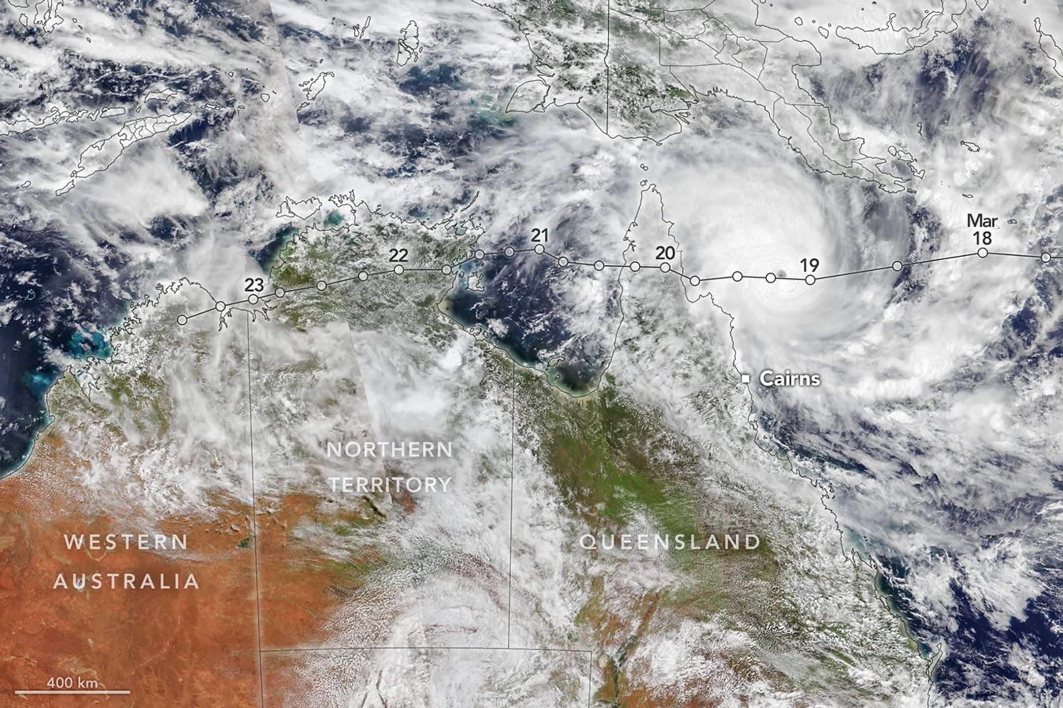
Tropical Cyclone Narelle traced a long path across the northern edge of Australia, bringing damaging winds and rain to areas already saturated with abundant precipitation. The system made separate landfalls in three different states and territories between March 20-23, 2026. 

The accompanying satellite image from the VIIRS (Visible Infrared Imaging Radiometer Suite) on the NOAA-21 satellite shows Narelle on March 19. By that time, the tropical cyclone was poised to make its first and most powerful landfall after intensifying over the Coral Sea. Sea surface temperatures along its path were 0.5–1.0 degrees Celsius above average, experts noted, which helped fuel its rapid intensification. 

As it approached Queensland, the storm intensified to a category 5 on Australia’s tropical cyclone scale with maximum sustained winds up to 225 kilometers (140 miles) per hour—equivalent to a category 4 hurricane on the Saffir-Simpson wind scale. However, because Narelle’s structure was compact by cyclone standards, the most damaging winds extended a relatively short distance from its core. Narelle reached the Cape York Peninsula, a sparsely populated region in northern Queensland, on the morning of March 20. 

Image credit: NASA Earth Observatory/Michala Garrison