Asian Surveying & Mapping
Breaking News
Japan Eyes Sovereign D2D Satellite Network
Japan plans to select a proposal this month for...
China schedules Long March 10B rocket launch and recovery attempt
HELSINKI — China is set for a debut flight...
BRICS space agencies meet begins in Bengaluru
Heads and senior representatives of the space agencies of...
“India’s growing space ecosystem to drive global collaboration”, says ISRO Chairman V Narayanan after BRICS Space Agencies Meeting
"India's growing space ecosystem to drive global collaboration", says...
UAE aims to see Emirati on Moon in next 10 years, says MBRSC chief
UAE expects to have a presence on the Moon within...
Safran, SatSure partner to develop geospatial intelligence solutions for India
French aerospace giant Safran Electronics & Defense and Indian...
Singapore unveils road map to help develop international business standards and conformance
Singapore has unveiled plans to help develop international standards...
Adelaide University to run space and defence venture launchpad ahead of Australian Space Forum
Adelaide University’s Innovation & Collaboration Centre (ICC) will deliver...
Japan’s H3 rocket returns to space with successful launch after December setback
Japan’s flagship H3 rocket has returned to flight six...
KONGSBERG accelerates seabed mapping developments with Ocean Exploration Trust expedition aboard Exploration Vessel Nautilus
KONGSBERG and the Ocean Exploration Trust (OET) are set...

March 10th, 2026
Ailing “Megaberg” Sparks Surge of Microscopic Life 

Iceberg A-23A has had a more eventful run than most of the large Antarctic icebergs that have calved from the continent’s ice shelves in recent decades. Over its winding, 40-plus-year journey, the “megaberg”spent decades grounded in the Weddell Sea before drifting north, twirling in an ocean vortex for months, and nearly colliding with an island in 2025. 

By 2026, the iconic iceberg, sopping with meltwater and shedding smaller bergs as it moved into warmer ocean waters, put on one more show. The chunks of ice and frigid glacial meltwater left in its wake appear to have fueled a surge in phytoplankton abundance, known as a bloom, observed in surface waters by NASA satellites. 

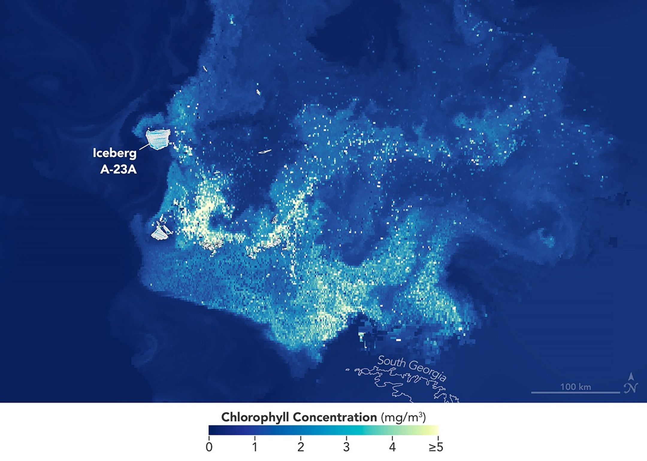
On Jan. 25, 2026, the OCI (Ocean Color Instrument) on NASA’s PACE (Plankton, Aerosol, Cloud, Ocean Ecosystem) satellite detected plumes of chlorophyll-a drifting around the remaining bergs and debris field. Researchers use chlorophyll concentrations as a marker of phytoplankton abundance. 

Image credit: NASA Earth Observatory images by Michala Garrison, using PACE data from the NASA Ocean Biology Distributed Active Archive Center OB.DAAC, and Landsat data from the U.S. Geological Survey.