
Asian Surveying & Mapping
Breaking News
ISRO Maps Over 2,000 Glaciers, 3,219 Glacial Lakes in Ladakh for Disaster Management
SRINAGAR: The Indian Space Research Organisation (ISRO) and other...
China Closes the Satellite Gap in Space Race With the U.S.
China aims to match the U.S. as the world’s...
IIT-Tirupati hosts fifth BRICS working group meeting on geospatial technologies
The Indian Institute of Technology-Tirupati (IIT-Tirupati), in collaboration with...
South Korea launches 4th Earth observation satellite from US
South Korea on Tuesday launched its fourth Earth observation...
Korea AeroSpace Administration Unveils K-Space Vision
Agency Will Benchmark European Aerospace Clusters and Explore Joint...
Japan space agency conducts Epsilon rocket engine test after failures
TOKYO - The Japan Aerospace Exploration Agency on Thursday...
UAE to boldly go with programme to boost nation’s expertise in space sector
A programme has been announced to enhance Emirati expertise...
China is building a ‘Mach 26 asteroid hammer’ to strike space rocks before they hit Earth
The Earth revolves in a cosmic system which is...
Nigeria and Benin Strengthen Border Surveillance with Geospatial Technology
The partnership was highlighted during a strategic meeting at...
IIT-Tirupati hosts fifth BRICS working group meeting on geospatial technologies
The Indian Institute of Technology-Tirupati (IIT-Tirupati), in collaboration with...

January 26th, 2026
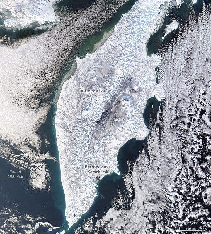
Snow Buries Kamchatka 

Russia’s Kamchatka Peninsula has been among the areas hit hard by cold and snowy weather in December 2025 and January 2026. More than 2 meters (7 feet) of snow fell in the first two weeks of January, following 3.7 meters in December, according to news reports. Together, these totals make it one of the snowiest periods the peninsula has seen since the 1970s, according to Kamchatka’s Hydrometeorology Center. The onslaught brought Petropavlovsk-Kamchatsky, the regional capital, to a standstill, with reports of large snowdrifts burying cars and blocking access to buildings and infrastructure.

This image, acquired by the MODIS (Moderate Resolution Imaging Spectroradiometer) instrument on NASA’s Aqua satellite, shows fresh snow blanketing the peninsula’s rugged terrain on Jan. 17, 2026. Several circular, snow-covered volcanic peaks are visible across the peninsula, one of the most volcanically active areas in the world. Petropavlovsk-Kamchatsky, home to more than 160,000 people, sits along Avacha Bay—a deep, sheltered bay formed by a combination of tectonic, volcanic and glacial activity. 

Image Credit: NASA Earth Observatory image by Lauren Dauphin, using MODIS data from NASA EOSDIS LANCE and GIBS/Worldview.