Asian Surveying & Mapping
Breaking News
Chandrayaan-3 launch window opens from July 12: Isro chief
New Delhi- The launch window for India’s third lunar...
Arianespace will launch Kompsat-6 with Vega C for Korea Aerospace Research Institute
Arianespace will launch Kompsat-6 with Vega C for Korea...
New Zealand launches new National Space Policy
The New Zealand Government has launched a new National Space...
UAE Space Agency launches Geospatial Analytics Platform Hackathon
The UAE Space Agency launched the inaugural edition of the...
45th Asian Summit on Remote Sensing to be held in Sri Lanka next year
The 45th Asian Summit on Remote Sensing, the premier...
North Korea says its rocket launch failed, 1st spy satellite lost
The launch of North Korea's first spy satellite was...
Singaporean alliance organizes geospatial-oriented AI challenge
In collaboration with AI Singapore, the Singapore Land Authority...
Saudi Arabia launches $207m geological mapping project
The Kingdom of Saudi Arabia has unveiled the Geological...
North Korea tells neighboring Japan of plans to launch satellite, safety warning issued
North Korea informed neighboring Japan on Monday that it...
Outsight Expands into Asia-Pacific with a New Hong Kong Office to Propel the Deployment of of It’s 3D Lidar Software
Following its recent expansion across Europe with the establishment...
seismic image

“Regulatory changes in Australia make this market more attractive for multi-client investment and TGS is excited to acquire seismic data in this new market, an area where industry believes there is high exploration potential. This Australia 3D project is consistent with our strategic plan and represents a new milestone of growth for TGS in a promising region,” commented Rod Starr, Senior VP Africa, Middle East and Asia Pacific for TGS.” 

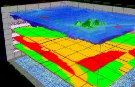
Fugro has been involved in 3D seismic imaging offshore Australia. SeisWorks 3D seismic interpretation software by Haliburton “provides innovative 3D viewing and interpretation capabilities and easy-to-use interpretation productivity tools to support and enhance horizon and fault interpretation. It is the industry standard for 3D seismic data analysis and interpretation. With SeisWorks 3D software, interpreters can work with a 2D project and multiple 3D projects concurrently for great interpretation flexibility.”

The market is expanding as the use and demand for 3D seismic products continues to grow, particularly where energy sources are in demand.