
Asian Surveying & Mapping
Breaking News
India-Japan looking to deepen economic engagement, eye greater cooperation in chips, space: Suzuki
New Delhi, Oct 4: India and Japan are looking...
Genesys International bags ₹283 crore World Bank-funded contract for Ahmedabad digital twin
The project will map 625 sq km, survey 25...
China launches new remote sensing satellite group
TAIYUAN, Sept. 24 (Xinhua) -- China launched a new...
Ahmad Belhoul Al Falasi to lead UAE delegation at IAC 2026
UAE delegation will bring together government entities, research institutions...
Korea Signs Space Cooperation MOU With Mexico
A path is opening for domestic space companies to...
China’s space diplomacy lifts Pakistani astronaut toward orbit
KARACHI, Sept 28 (Reuters) - Two Pakistani pilots are...
NV5 Global stock expands geospatial reach with $303 million deal
NV5 Global stock is linked to a Quantum Spatial...
EU and Korea deepen cooperation on secure satellite connectivity
Today, the European Commission and the Republic of Korea...
Ghana, Japan explore deeper cooperation in space technology
Ghana and Japan are exploring deeper cooperation in space...
China conducts four launches inside 48 hours as launch options diversify
HELSINKI — China carried out four launches in quick...

January 12th, 2026
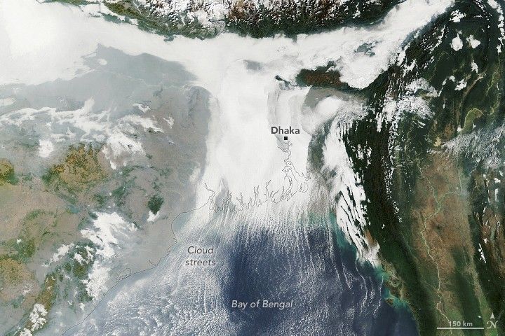
Ganges Delta Under a Winter Shroud of Fog 

Winter weather took hold across the Indo-Gangetic Plain in early January 2026, bringing dense fog and cold temperatures to much of the flat, fertile lands that span from Pakistan and northern India to Bangladesh. 

This image shows low-lying clouds over the delta on the morning of Jan. 6, 2026, captured by the Moderate Resolution Imaging Spectroradiometer (MODIS) on NASA’s Terra satellite. Dense fog, particularly radiation fog, is common this time of year, forming when ground temperatures are cool, winds are light and moisture is abundant near the surface. The meteorological departments of both Bangladesh and India called for moderate to very dense fog over the region that day amid an ongoing cold wave. 

Other relatively low-level clouds extend from the land areas and over the Bay of Bengal. These long, parallel bands of clouds, known as cloud streets, can form when cold air passes over warmer open water, gaining heat and moisture. Rising thermals ascend until they reach a temperature inversion that acts like a lid, forcing the air to roll into long, parallel rotating cylinders. Clouds develop where the air rises, while clear skies appear where the air sinks. 

Image Credit: NASA Earth Observatory image by Lauren Dauphin, using MODIS data from NASA EOSDIS LANCE and GIBS/Worldview