Asian Surveying & Mapping
Breaking News
Launch of Australia’s 1st orbital rocket, Gilmour Space’s Eris-1, delayed again
Update for 6:15 p.m. ET on July 1: Gilmour Space...
SAASST, UAE Space Agency strengthen scientific partnership
SHARJAH- Prof. Hamid M.K. Al Naimiy, Director of the...
Shubhanshu Shukla to speak to students and ISRO scientists this Friday
Indian astronaut Shubhanshu Shukla will interact with school students...
ISRO hands over 10 advanced technologies to Indian firms in major push for space commercialisation
The Indian Space Research Organisation (ISRO) has transferred ten...
DIGIPIN Launched: India Embraces Geospatial Precision in Digital Addressing
IIT Hyderabad (IITH), in partnership with the Department of...
HAL to build, market Isro’s SSLV in landmark deal
New Delhi, Jun 20: In a historic move for...
Taiwan developing space capabilities for all-weather imaging
TAIPEI (TVBS News) — Taiwan is advancing its space...
Honda hails successful test of reusable rocket as it looks to get into the space business
Tokyo — Japan's second-biggest carmaker, Honda, has successfully tested...
China’s space program provides larger platform for broader international cooperation
BEIJING -- Experts from China's manned space program said...
India To Launch $1.5 Billion Joint Earth Mission With NASA In July
National Aeronautics and Space Administration (NASA) and the Indian...

Products

image

Wednesday, May 11th, 2011

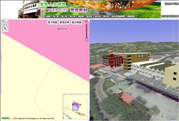
SuperWebGIS Designs Eco-cultural Web-GIS for Environment Navigation

SuperGeo Technologies, the leading global provider of complete GIS software and solutions, designed an Eco-cultural GIS website for Tungnan University to integrate the campus navigation system with the information of surrounding environment, ecology and culture. Aimed to...

Wednesday, May 11th, 2011

New CorelCAD Delivers Precision and Power at an Affordable Price

Corel today announced the expansion of its award-winning graphics and technical illustration portfolio with the introduction of CorelCAD, a powerful and affordable CAD solution that delivers native DWG (industry standard CAD file format) support, and the ability...

Wednesday, May 11th, 2011

FOIF – DS03 Training in High-precision Measurement for Ground Water Level

The Suzhou Science and Technology School of Environmental and Engineering Professor Zhang Xufu , teacher for the company to lead the marketing department, GNSS marketing, import and export department, technology center, quality control department and some other...

Tuesday, May 10th, 2011

CHC Introduces New GPS Mapping Solutions

CHC today announced the availability of Nava GPS Handheld series designed for any meter-level GPS mapping applications such as in forestry, agriculture, utilities, and local government, which are mainly capturing data about assets. Nava GPS are affordable, easy-to-use...

Monday, May 9th, 2011

Feature-level Security for ArcGIS Server

con terra GmbH, one of the market leader in providing solutions for Spatial Data Infrastructures and Enterprise GIS, announces a new release of the long-established securityManager, now with support for feature-level security on ArcGIS...

Sunday, May 8th, 2011

Geoscience Australia – Update on Geophysical Data

Geoscience Australia is a prescribed agency within the Resources, Energy and Tourism portfolio, and our Minister is The Hon Martin Ferguson AM MP. Geoscience Australia is a world leader in providing first...

Sunday, May 8th, 2011

Marine Expert iXSurvey Chooses MrSID

iXSurvey is a multinational company with offices in Australia, France and the UK that specialises in the measurement and understanding of the physical, chemical and biological marine environment. The company’s experienced and talented team of surveyors carries...

Thursday, May 5th, 2011

EMS Technologies Announces Satellite Communications Study for The Commonwealth of Australia

EMS Technologies, Inc. (NASDAQ: ELMG) a leading provider of aero connectivity and mobile resource management solutions today announced the initiation of a new satellite communications study for The Commonwealth of Australia. The study will assess the feasibility...

Thursday, May 5th, 2011

EMS Technologies to Support Russian GLONASS System

Global connectivity leader, EMS Technologies, Inc. announced today that products and solutions offered through its Global Resource Management unit will soon be outfitted for compatibility with GLONASS, a constellation of 26 positioning and navigation satellites operated by...

Thursday, May 5th, 2011

GRAPHISOFT Announces ArchiCAD 15

GRAPHISOFT announced today ArchiCAD 15, the latest version of its premium design software for architects. ArchiCAD 15 enriches architectural forms available for designers to unleash their creative minds. The new version also expands the scope of the BIM...

Page 408 of 427 1 403 404 405 406 407 408 409 410 411 412 413 427