
Sunday, January 30th, 2011
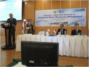
In these seminars, the Indonesian government under the high interest, and supervision and inspection and supervision of projects bid for contract work related to disaster management of water resources. There has been a lively debate, with further...
Saturday, January 29th, 2011
Web-based GIS (Geographic Information System) application being developed for Gobichettipalayam Municipality in Erode district is likely to be made available to the public in April this year. The application will be utilised in urban planning and civic services,...
Thursday, January 27th, 2011
To further the development of the Quazi-Zenith Satellite System (QZSS) program, the Japanese Aerospace Exploration Agency (JAXA) has selected Spirent Communications’ testing solutions to verify performance of its satellite receivers. Responsible for the development of initial QZSS...
Wednesday, January 26th, 2011
The Satellite Technology for the Asia-Pacific Region (STAR) program is an international initiative to develop small satellites in collaboration with engineers and researchers from the Asia-Pacific region. STAR Program aims to 1) Provide opportunities to build capacity for Space...
Tuesday, January 25th, 2011
A new project for setting up a 3-dimensional model of the Emirate of Abu Dhabi has been put into motion, announced the Municipality of Abu Dhabi City (ADM) on Monday in a statement. It is considered to...
Monday, January 24th, 2011
For the first time in Nepal, a wild tiger fitted with satellite collar was translocated from the Chitwan National Park (CNP) to Bardia National Park (BNP) today. CNP authorities had rescued the injured male tiger from the...
Saturday, January 22nd, 2011
A new set of national engineering guidelines for dealing with storm and floodwaters are bogged down in funding problems, while Victoria's major flood strategy is more than two years behind schedule and still incomplete. Urban flooding is...