Thursday, February 14th, 2019
Airbus is expanding its aerospace activities at its site in Ottobrunn/Taufkirchen, near Munich, Germany. Bavarian Minister-President Markus Söder and Airbus Defense and Space Chief Executive Officer (CEO) Dirk Hoke, gave the green light for the modernization of...
Thursday, February 14th, 2019
Not-for-profit organisation EuroGraphics – which represents official bodies including UK national mapping agency Ordnance Survey – is leading the Open European Location Services (Open ELS) project and has indicated it expects to deliver the portal in April....
Thursday, February 14th, 2019
WASHINGTON — As the Chilean Air Force looks to replace an aging spy satellite it bought from Airbus a decade ago, the European aerospace giant is facing competition for the project from Ball Aerospace, Lockheed Martin and Maxar...
Thursday, February 14th, 2019
TOKYO -- A Japanese map platform developer funded by leading automakers will acquire an American peer affiliated with General Motors, seeking a stronger position for challenging Google and Chinese rivals in a vital area for self-driving cars....
Thursday, February 14th, 2019
North Nias Marine and Fisheries Agency head Sabar Jaya Telaumbanua in North Sumatra province could not hide his excitement when witnessing local fishermen in the regency return with a big catch --much bigger than usual. Read More at Jakarta Times

Wednesday, February 13th, 2019
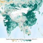
The world is literally a greener place than it was 20 years ago, and data from NASA satellites revealed a counterintuitive source for much of this new foliage: China and India. A new study shows that the...
Wednesday, February 13th, 2019
Friedrichshafen, Madrid – Airbus Defence and Space and Hisdesat Servicios Estratégicos, S.A. have generated the first joint TerraSAR-X / PAZ Radar Interferogram. This milestone demonstrates the missions’ capacity for cross-sensor interferometry, whose processing is among the most...
Wednesday, February 13th, 2019
ACEINNA today announced that it has earned the coveted Golden Mousetrap Award for its OpenIMU Platform for ADAS and autonomous vehicle navigation and localization. OpenIMU enables advanced, easy-to-deploy localization and navigation algorithm solutions for a fraction of...
Wednesday, February 13th, 2019
CORNISH, Maine - SpatialTEQ Inc., publisher of North America's most advanced cloud-based business mapping software, Www.MapBusinessOnline.com, offers an affordable solution for customer visualizations against an accurate business map as a key business mapping feature. Detailed user-base application analysis...
Wednesday, February 13th, 2019
SIMI VALLEY, Calif.-AeroVironment, Inc. (NASDAQ: AVAV), a global leader in unmanned aircraft systems for both defense and commercial applications, today introduced the next generation of its Quantix™ VTOL hybrid drone and the AeroVironment Decision Support System™ (AV DSS)...