Wednesday, July 17th, 2019
(Harrisburg, Pa.) When the Department of Veterans Affairs (VA) National Cemetery Administration (NCA) wanted to ensure accuracies and data for veteran cemetery records, they turned to GeoDecisions®, Gannett Fleming’s geospatial technology division. GeoDecisions is honored to provide...
Wednesday, July 17th, 2019
GSSI, the world’s leading manufacturer of ground penetrating radar (GPR) equipment, is pleased to announce a distribution partnership with Blinken Tools AB, headquartered in Karlstad, Sweden. This alliance focuses on expanding GSSI’s presence in the Scandinavia region...
Wednesday, July 17th, 2019
Increased Capabilities Save Days of Setup Time for Real-Time Structural Monitoring Projects SUNNYVALE, Calif., — Trimble (NASDAQ: TRMB) introduced today the latest version of its core real-time monitoring software—Trimble® 4D Control software. Version 5.0 provides new...

Tuesday, July 16th, 2019
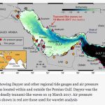
A major oil tanker expressway in the Persian Gulf once thought a low-risk area is actually a “highly vulnerable hotspot” for monster waves, new research reveals. Scientists were shocked when on a calm cloudy March day in...
Tuesday, July 16th, 2019
OREM, Utah - SpotterRF was awarded a patent by the U.S. Patent office for the 3D-500 360° full-dome radar that was developed to detect drone attacks and is the latest in a line of counter-drone radars from SpotterRF....
Tuesday, July 16th, 2019
LAS VEGAS - More than 100 of the world's top UAS vendors have signed on to showcase their solutions at the 2019 Commercial UAV Expo Americas, far more than any other commercial drone event in North America....
Tuesday, July 16th, 2019
Cesium and Analytical Graphics Inc. (AGI) are thrilled to announce the launch of Cesium, a newly independent company and the first spinout company from AGI. The new venture kicks off with a $5 million Series A investment...
Tuesday, July 16th, 2019
Europa Technologies has won two awards at the Esri User Conference 2019 in San Diego, California. Both awards were given to a map called “Streets of Gold” which was exhibited at the event’s Map Gallery. The first...
Tuesday, July 16th, 2019
— The American Geographical Society (AGS) has been awarded a grant by Omidyar Network to launch a world-wide conversation on the ethics of geospatial technologies. Designated “EthicalGEO,” this initiative calls on thinkers from...
Tuesday, July 16th, 2019
By combining Building Information Modelling (BIM) with geospatial technologies, Ordnance Survey (OS) is breaking down barriers in Singapore. OS has spent two years in the South East Asian nation championing the use of BIM data and its...