
Monday, January 1st, 2018
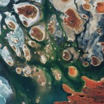
Brown hills speckle the eastern part of Australia’s Lake MacKay in this image from the Copernicus Sentinel-2B satellite. The lake lies at the edge of the Great Sandy Desert, which covers nearly 285,000 square kilometers. Located on...
Friday, December 22nd, 2017
Redlands, California—Esri, the global leader in spatial analytics, today announced the publication of Imagery and GIS: Best Practices for Extracting Information from Imagery. The book teaches the fundamentals of collecting imagery via remote sensing systems and then...
Friday, December 22nd, 2017
TerraSim announced today the release of TerraTools 5.5, the latest version of its industry leading virtual terrain generation software, just in time for the holidays. TerraTools 5.5 contains a variety of new features, enhancements, maintenance updates, and...
Thursday, December 21st, 2017
SI Imaging Services (“SIIS”) today announced the signing of a reselling agreement with UrtheCast Corp. and its subsidiary, the Earth Observation company Deimos Imaging, a leading provider of Earth Observation products and services for the mutual global...
Thursday, December 21st, 2017
Madrid – Loading and transport of the Spanish Earth observation satellite, PAZ, is underway. Airbus engineers in Madrid are installing the 1,400 kg satellite into the container that will protect it during its journey to the Vandenberg...
Thursday, December 21st, 2017
WATERLOO, ON - Teledyne DALSA (NYSE: TDY), a Teledyne Technologies company and global leader in machine vision, announces its new high resolution camera -- the Falcon4™ 86M. Available in monochrome and color, Falcon4 models combine incredibly large...
Thursday, December 21st, 2017
Hallowell, Maine - Blue Marble Geographics (bluemarblegeo.com) is pleased to announce that Beijing E-Carto Technologies Co., Ltd. has joined the growing list of partner companies reselling and supporting Blue Marble's products throughout the world. Focusing on the...
Thursday, December 21st, 2017
Atos has been selected by the European Commission and European Space Agency to deliver Copernicus Data and Information Access Services (DIAS) in a broad European consortium with T-Systems, Thalès Alénia Space, DLR German Aerospace Center, EOX IT...
Thursday, December 21st, 2017
PALO ALTO, Calif. ― SSL, a business unit of Maxar Technologies (formerly MacDonald, Dettwiler and Associates Ltd.) (NYSE: MAXR; TSX: MAXR) and a leading provider of innovative satellites and spacecraft systems, announced today that the Restore-L mission...
Thursday, December 21st, 2017
British ‘New Space’ pioneer Earth-i today announced that images and video from its new prototype satellite due for launch early January 2018 will be managed, catalogued and geometrically corrected using software from Swedish photogrammetry and imagery specialist,...