Asian Surveying & Mapping
Breaking News
South Korea is gearing up to become space powerhouse
From Samsung’s smartphones to SK Hynix’s semiconductors, South Korean...
Indian space tech startup to launch six satellites in 2024 via ISRO and SpaceX rockets
Pixxel, a Bengaluru-based space tech startup, plans to launch...
China’s secretive spaceplane releases object into orbit
HELSINKI — China’s experimental reusable spacecraft has released an...
Japan to create flood projection maps for 4 Southeast Asian nations
Japan plans to create flood projection maps for Indonesia,...
Net Insight and ACES extend their partnership for GNSS-independent infrastructure in Saudi Arabia
Net Insight and ACES extend their partnership to facilitate...
Saudi Arabia’s PIF launches Neo Space Group to boost satellite and space sector
Saudi Arabia’s Public Investment Fund (PIF) announced the establishment of...
EarthCARE satellite to probe how clouds affect climate
Will clouds help cool or warm our world in...
China stages mock missile strikes on Taiwan, jets with live missiles used in drills
BEIJING/TAIPEI (Reuters) - China staged mock missile strikes and...
Beijing-3C remote sensing satellite constellation captures its first image
The Beijing-3C satellite constellation captured its first image on...
Swift Navigation and SK Telecom Partner to Accelerate the Deployment of AI-Powered Location-Based Products in Korea
SAN FRANCISCO - Swift Navigation (“Swift”), a market leader...

Services

image

Sunday, March 13th, 2011

Earthquake in Japan: Detailed Satellite Images Received

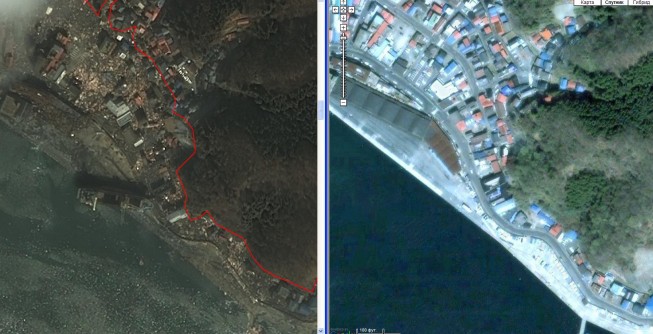
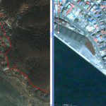
Detailed satellite images of the territory of Japan were received, where a series of earthquakes were registered on March 11 in its north-eastern parts. According to the Main Meteorological Service of the country the 8.9 magnitude earthquake...

Saturday, March 12th, 2011

Esri Assists Japan Earthquake and Tsunami Response

In response to the devastating Japan earthquake and tsunami, Esri is providing assistance to a myriad of organizations involved in the disaster response. The company is working closely with both domestic and international...

Friday, March 11th, 2011

Urals Federal University – Now Handling Satellite Data in Real-time

The center of Space Monitoring will start to operate at the Urals Federal University. Opening ceremony of the Center and putting into operation of the Earth remote sensing data reception station is to be held on March...

Wednesday, February 23rd, 2011

Autodesk Launches Clean Tech Partner Program in Japan

Autodesk, Inc. a leader in 3D design, engineering and entertainment software, announced the expansion of its Clean Tech Partner Program to Japan. The Japan program marks the first step in a planned expansion into Asia Pacific. The...

Tuesday, February 22nd, 2011

New Zealand – Canterbury Incident Map

At 12:51 p.m. on February 22, 2011 a magnitude 6.3 earthquake hit the South Island of New Zealand near the city of Christchurch. The Esri distributor in New Zealand, Eagle Technology Group in collaboration with Environment Canterbury has...

Tuesday, February 22nd, 2011

C-Nav Chosen for Osiris Projects Vessel

C-Nav, the premier supplier of international GNSS Precise Point Positioning services, will provide the GNSS positioning system for Osiris Projects latest new-build survey vessel, the SV Bibby Tethra. C-Nav has been chosen to provide...

Tuesday, February 22nd, 2011

WALGA Joins A-Spec Consortium in West Australia

The  A-Spec  Group  welcomes WALGA  – the Western Australian Local Government Association to our consortium. WALGA and the A-Spec consortium have been working closely to address the benefits that the consortium members in Western Australia may derive from ensuring...

Tuesday, February 15th, 2011

GLONASS Monitors South Caucasian Railway

M2M Telematica group of companies introduced navigation solutions in one of South Caucasian Railway’ structural units, M2M PAO reports. South Caucasian Railway is a subsidiary of Russian Railway company. Under the M2M’s pilot projects, 50 items involved in...

Monday, February 14th, 2011

New-look Bus Route Maps Unveiled

The process of tracking destinations and planning bus journeys has been made easy following the launch of new-look bus routes and maps at all bus stops across Dubai. The Roads and Transport Authority (RTA) has started displaying improved...

Monday, February 14th, 2011

Spirent – Improving Railway Navigation

The use of GNSS in navigation, timing and related systems for transportation is ever increasing. The railways are no exception. There are various programmes underway looking at the application of GNSS to the railway for safety-critical functions....

Page 28 of 31 1 23 24 25 26 27 28 29 30 31