Asian Surveying & Mapping
Breaking News
Esri India Achieves 1 Million Users Milestone
Esri India, the leading provider of Geographic Information System...
Bank Negara, Malaysian Space Agency to bolster financial management ecosystem via space technology
KUALA LUMPUR: Bank Negara Malaysia has partnered with the...
Nepal’s president advisor resigns after criticising inclusion of Indian areas in map on new currency
The economic advisor to Nepal’s president on Sunday (May...
TASA to launch six satellites from 2026
The Taiwan Space Agency (TASA) yesterday said it plans...
Japan to provide flood risk maps for four South-East Asian countries – Indonesia, Vietnam, Thailand and Cambodia
JAKARTA/TOKYO: Japan plans to start providing flood risk maps...
Ecolab and ITE partners to harness water management knowledge for Singapore data center engineers
SINGAPORE, 29 APRIL 2024 – Nalco Water, an Ecolab...
NASA releases satellite photos of Dubai and Abu Dhabi before and after record flooding
NASA released photos of parts of Dubai and Abu...
Singapore releases 10-year Geospatial Master Plan
Singapore has launched its new Geospatial Master Plan (2024–33),...
Japan announces plans to launch upgraded observation satellites on new flagship rocket’s 3rd flight
TOKYO (AP) — Japan’s space agency announced Friday a...
Tesla China partners with Baidu for maps to clear FSD hurdle
Amidst Elon Musk’s unannounced trip to Beijing, China this...

Feature

Wednesday, June 16th, 2010

Asian Marine Spatial Data Infrastructures

Recent oil spill events in the Gulf of Mexico should cause others to awaken to the possibility that their coasts could be threatened by similar circumstances. Asian countries are now in a position to learn many...

Friday, June 11th, 2010

Aerial LiDAR Overview

LiDAR is another tool in the surveyor’s toolbox. It is capable of providing a three-dimensional X,Y,Z position with a possible accuracy of 5 cm.. The key components of aerial LiDAR instruments include: 

Thursday, June 10th, 2010

Resource Mapping of East China Sea Remains Tense

As countries have exhausted their terrestrial natural resource reserves, they are turning to sea-bed resources. Perhaps nowhere else in the world is this practice as politically charged as the East China Sea. Particularly...

Wednesday, June 9th, 2010

Mapping the Pacific Ocean

The Pacific Ocean plays a dominate role to the many countries and people of Asia. This contribution can be measured in many ways, from food to resources, transport and weather moderation. But how much do we...

Monday, May 10th, 2010

GPS Update Adds Accuracy

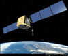
This month the U.S. Air Force begins the launch of new GPS satellites that will dramatically improve the accuracy of GPS signals. The IIF generation of satellites will eventually replace half of the existing satellite constellation, with...

Friday, May 7th, 2010

Least Squares Offer Incremental Accuracy Improvement

Building the government infrastructure for land record and land parcels involves the creation of a survey database of field measurement, geodetic survey control, and the surveyors’ boundary determinations. The cadastral dataset includes parcels, boundary lines, parcel corners,...

Sunday, May 2nd, 2010

Mining and the Value of 3D

Mining operations have used 3D technologies for many years. These technologies provide important benefits to both open-pit and underground mining operations. The technologies used to capture 3D information include aerial and satellite imagery, laser, global positioning systems...

Wednesday, January 9th, 2008

Robotic Lunar Explorers Closer

Odyssey Moon made its public debut on 6 December at the Space Investment Summit in San Jose, California. The company used the summit to announce that it has entered Google’s contest for a privately funded...

Wednesday, January 9th, 2008

Virtual Campus Model Print_button Print

Yi-Hsing Tseng, a professor of geomatics at the National Cheng Kung University in Taiwan gave people at the 28th ACRS a view inside a complex but highly detailed 3 D model of the campus. The model contains...

Tuesday, January 8th, 2008

Collins Bartholomew Revolutionises Atlas Production

A new edition of the Times Comprehensive Atlas of the World has just been published. The first edition for the new century is an advertisement for the power and beauty of GIS. Since John Bartholomew...

Page 50 of 53 1 45 46 47 48 49 50 51 52 53