Asian Surveying & Mapping
Breaking News
HAL to build, market Isro’s SSLV in landmark deal
New Delhi, Jun 20: In a historic move for...
Taiwan developing space capabilities for all-weather imaging
TAIPEI (TVBS News) — Taiwan is advancing its space...
Honda hails successful test of reusable rocket as it looks to get into the space business
Tokyo — Japan's second-biggest carmaker, Honda, has successfully tested...
China’s space program provides larger platform for broader international cooperation
BEIJING -- Experts from China's manned space program said...
India To Launch $1.5 Billion Joint Earth Mission With NASA In July
National Aeronautics and Space Administration (NASA) and the Indian...
Axiom-4 mission delayed again: ISRO confirms Subhanshu Shukla’s ISS spaceflight won’t launch before 22 June 2025
The Axiom-4 mission to the International Space Station has...
Mengzhou spacecraft for China’s moon-landing mission passes landmark test flight
China has completed the inaugural test flight of its...
Space application for ITMA Asia + CITME 2026 opens
Shanghai – Space application for the 2026 edition of...
Yanmar, Chia Tai and XAG Empower Thai Agriculture through Innovation
Bang Nam Priao District, Chachoengsao Province, Thailand – On...
bitsensing Signs MOU with IKIO Technologies to Advance AI-Based Traffic Monitoring on India’s Expressways, Highways and Municipal Areas
Backed by proven success in South Korea and Europe,...
sat_climate1

As RIA Novsti reported, “The Elektro-L 1 was designed to provide meteorologists with a wide variety of data, including weather analysis and forecasting on a global and regional scale. It also monitors changes in the climate. The satellite should be able to image the entire visible hemisphere of Earth at a resolution of 1 km per pixel (visible light band) and 4 km (IR band), every 30 minutes.”

The Russian SPUTNIK Server provides information on the current numbers and types of such satellites that the country has in space.

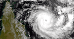
More recently we are beginning to see the development of personal and mobile weather monitoring applications for use with Smartphones and other mobile devices. Recent flooding in Vietnam, Pakistan and Australia is undoubtedly supporting the need for more useful information, particularly predictions. 

The Global Hydrology and Climate Centre of NASA also provides global information gathered through weather monitoring satellites.

As Russia proceeds to launch new meteorological satellites, China is also likely to follow as that country pursues greater investment in the development of food production technologies. These capabilities will support the broader use of precision agriculture as well as the immediate needs for predicting natural disasters related to climate.