
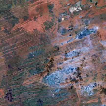
Part of the Gibson Desert in Western Australia is featured in this image captured by the Φsat-2 mission in June 2025.
Covering an area of more than 150,000 square kilometers, the desert consists of gravel terrains covered by desert grasses as well as red sandy plains and dune fields. As we can also see in the image, the typical soil surface colors range from reddish brown to red, owing to the iron-rich sediments. Additionally, the dry climate and weather trigger soil oxidation, giving the landscape its distinctive warm colors.
Parallel sand dune ridges are a defining characteristic of the area and can be seen spreading across the image. These are shaped by the wind and can stretch for tens of kilometers.
The largest blue feature visible in the lower part of the image is a dry lakebed, where the Fortescue River empties. In this region, rivers are mainly ephemeral, which means they remain dry for most of the year and flow only temporarily and briefly, usually in direct response to precipitation. The Fortescue River is dry in this image because no significant rain fell during the days before the acquisition.
Inland drainage is typical of most of Western Australia, and the great majority of the lakes here are saline dried-up lakebeds, rather than freshwater bodies. The partially white body of water seen at the top is part of the Fortescue Marsh wetlands rather than a classic permanent lake. The white color within the lake is due to the presence of sediments in the water.
The Fortescue Marsh is a vast seasonal floodplain with lakes, marshes and pools that act as a natural water retention basin during and after rains. It is nationally recognised as a wetland of importance and supports diverse flora and fauna that has adapted to the arid and ephemeral river environment.
Image Credit: ESA
