
Asian Surveying & Mapping
Breaking News
Palakkad Celebrates as NASA Astronaut Anil Menon Set for First Space Mission
Thiruvananthapuram, July 13, 2026: Kerala’s Palakkad district is set to...
G20 satellite is expected to be launched in 2027: ISRO Chairman
ISRO Chairman V. Narayanan has said that the G20...
Unidentified metal spheres found on Australian beach are ‘debris from a foreign rocket body’, space agency says
The Australian Space Agency says the objects "appear to...
Singapore and Japan sign agreement to strengthen space collaboration
SINGAPORE: The space agencies of Singapore and Japan signed...
Japan space probe skims asteroid in test for planetary defense
A Japanese space probe performed a flyby of a...
Hong Kong-developed ‘Eye for Space’ now operating aboard Tiangong space station
Hong Kong’s first home-grown astronaut, Lai Ka-ying, assembled and...
ISRO conducts first SOLVE ground test important for Gaganyaan missions
Sub-Orbital Launch Vehicle for Experiments (SOLVE) solid motor was...
New 3D Detection Method for Detecting Atmospheric Rivers in Antarctica
Researchers in Japan demonstrate how vertically layered atmospheric rivers...
Uttar Pradesh Govt launches Special Land Measurement Campaign
The Uttar Pradesh government yesterday launched the statewide Digi...
Japan Eyes Sovereign D2D Satellite Network
Japan plans to select a proposal this month for...
  • Feb 5, 2024
  • Comments Off on Images Taken by JAXA’s Smart Lander for Investigating Moon 
  • Feature
  • 4362 Views

February 5th, 2024
Images Taken by JAXA’s Smart Lander for Investigating Moon 

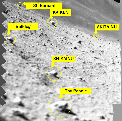
The Japan Aerospace Exploration Agency (JAXA), along with the University of Aizu and Ritsumeikan University, released images captured by the Multi-Band Camera (MBC) onboard the Smart Lander for Investigating Moon (SLIM). 

After the moon landing and before shutting down of the spacecraft power, MBC released the locking mechanism to withstand the impact upon launch and landing, then conducted scanning operations. The scanning is performed by moving the adjustable mirror and is for preliminary examination of the rocks of scientific interest that are situated around the SLIM landing site. The accompanying figure shows a landscape image created by synthesizing 257 low-resolution monochrome pictures. Based on this landscape image, the team is sorting out rocks of interest, assigning a nickname to each of them, with intent of communicating their relative sizes smoothly by the names. Preparation is underway to promptly conduct 10-band high-resolution spectroscopic observations once the solar illumination condition improves and SLIM recovers by the power generated by the solar array. 

Image Credit: JAXA, RITSUMEIKAN UNIVERSITY, THE UNIVERSITY OF AIZU