Supporting the Canadian Hydrographic Service, these data will be used to update nautical charts and evaluate emerging technologies.
VICTORIA, British Columbia — The Department of Fisheries and Oceans Canada (DFO) contracted with Woolpert Canada to collect aerial topographic and bathymetric lidar data and high-resolution, four-band imagery at select sites along the southwest coast of British Columbia. These data, collected with associated oceanographic and ground survey information, will support the missions of the Canadian Hydrographic Service (CHS). The data will be used to update nautical charts and provide vital information for marine research and to support indigenous communities.
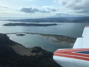
Woolpert is flying this project with its dual port Cessna 404 with the firm’s Leica Hawkeye 4X lidar sensor, navigating water clarity, tide levels and weather conditions. Data are scheduled to be delivered to DFO by the end of June.
Woolpert Vice President and Hydrographer Ben Hocker said as part of this project, additional data are being collected over portions of the Gulf Islands National Park Reserve. This region will be used as a reference surface to evaluate emerging geospatial and hydrographic technologies. The information collected by Woolpert will complement data collected by CHS using satellite, multibeam, sonar and vessel-mounted mobile laser scanners.
“The intent is to develop an area where multiple types of data will be collected using various platforms and sensors to evaluate and compare their effectiveness for marine research and charting,” Hocker said. “This industry is changing daily due to advancing technology, and this evaluation will help CHS identify the most accurate and effective tools for multiple marine research and navigation safety needs.
About Woolpert
Woolpert is the premier architecture, engineering, geospatial (AEG) and strategic consulting firm, with a vision to become one of the best companies in the world. We innovate within and across markets to effectively serve public, private and government clients worldwide. Woolpert is an ENR Top 150 Global Design Firm, recently earned its fifth-straight Great Place to Work certification and actively nurtures a culture of growth, inclusion, diversity and respect. Founded in 1911 in Dayton, Ohio, Woolpert has been America’s fastest-growing AEG firm since 2015. The firm has over 1,100 employees and 42 offices in three countries. For more, visit woolpert.com
