Asian Surveying & Mapping
Breaking News
Astranis clinches $115 million Taiwan deal despite satellite setback
TAMPA, Fla. — Astranis has signed a $115 million...
UAE and Egypt Strengthen Space Collaboration with New MoU
In a milestone development for Arab space collaboration, the...
Seoul launches 4th spy satellite to boost North Korea surveillance
South Korea’s military now operates an increasingly integrated cluster...
Indonesia seeks space defense cooperation with Japan’s military
Jakarta (ANTARA) - The Ministry of Defense of Indonesia...
China Launches 3 Astronauts To Its Space Station
The spacecraft Shenzhou-20 and the crew lifted off atop...
Former Isro chairman K Kasturirangan dies in Bengaluru at 84
Dr. Kasturirangan led the Isro, the Space Commission, and...
South Korea is converting an abandoned coal mine into a moon exploration testing ground
South Korea is transforming abandoned coal mines into testing...
ISRO to Launch Chandrayaan-5 With Japan, Plans Space Station
Dr. V. Narayanan, Chairman of the Indian Space Research...
Russia and China are threatening SpaceX’s Starlink satellite constellation, new report finds
SpaceX's Starlink satellite constellation is facing threats from Russia...
China and Pakistan agree to fly 1st foreign astronaut to Chinese space station
For the first time, the Chinese space program will train...
ATIS

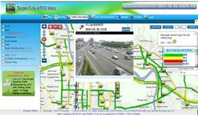
“These are premier private awards, commemorating the excellence and advancement in the field of geospatial.” indicates GIS Development. The application developed by SuperGeo has successfully shown the outstanding usage of geospatial technologies in transportation and traffic management. The project was authorized by Taipei City Government, which provides many kinds of traffic information, such as subway services, parking lots, road speeds, and CCTV, from many sectors. SuperGeo Technologies developed a WebGIS application integrating rich traffic data from dissimilar resources on the same platform. The GIS Web can display complex traffic data for all the public in real time conveniently.

The application used SuperWebGIS, the Internet map server software developed by SuperGeo Technologies, as the user interface platform. Organizations can deliver dynamic maps and share geospatial data via the Web promptly by the software.

The WebGIS application has demonstrated how GIS technologies can help the management combine diversified types of real-time traffic information in one platform easily.  

More information of ATIS Web is available at www.supergeotek.com/ Library_2_201005.aspx More information of the Award: http://geospatialworldforum.org/2011/conference/ award.htm