Asian Surveying & Mapping
Breaking News
HAL to build, market Isro’s SSLV in landmark deal
New Delhi, Jun 20: In a historic move for...
Taiwan developing space capabilities for all-weather imaging
TAIPEI (TVBS News) — Taiwan is advancing its space...
Honda hails successful test of reusable rocket as it looks to get into the space business
Tokyo — Japan's second-biggest carmaker, Honda, has successfully tested...
China’s space program provides larger platform for broader international cooperation
BEIJING -- Experts from China's manned space program said...
India To Launch $1.5 Billion Joint Earth Mission With NASA In July
National Aeronautics and Space Administration (NASA) and the Indian...
Axiom-4 mission delayed again: ISRO confirms Subhanshu Shukla’s ISS spaceflight won’t launch before 22 June 2025
The Axiom-4 mission to the International Space Station has...
Mengzhou spacecraft for China’s moon-landing mission passes landmark test flight
China has completed the inaugural test flight of its...
Space application for ITMA Asia + CITME 2026 opens
Shanghai – Space application for the 2026 edition of...
Yanmar, Chia Tai and XAG Empower Thai Agriculture through Innovation
Bang Nam Priao District, Chachoengsao Province, Thailand – On...
bitsensing Signs MOU with IKIO Technologies to Advance AI-Based Traffic Monitoring on India’s Expressways, Highways and Municipal Areas
Backed by proven success in South Korea and Europe,...

July 14th, 2020
Dewberry to Provide Enhanced QL1 Lidar for Florida Panhandle

Firm to provide data for U.S. Geological Survey following widespread impacts of Hurricane Michael.

Dewberry, a privately held professional services firm, announced that it has been selected by the U.S. Geological Survey (USGS) to provide updated base elevation models for the panhandle region of Florida, which was heavily impacted by Hurricane Michael in 2018.

The firm has collected data for approximately 8,000 square miles of Florida, including the counties of Washington, Bay, Jackson, Calhoun, Gulf, Gadsden, Liberty, Franklin, Leon, Wakulla, and portions of Walton, Holmes and Jefferson. The data will be processed to quality level 1 (QL1) specification requirements, which is >8 points per square meter, with roughly 5,700 square miles at the Florida enhanced hydrography QL1 specification requirements and the remaining 2,550 square miles at the USGS National Geospatial Program Lidar Base Specification version 2.1.

“We are thrilled to help USGS, partner federal agencies, and the state of Florida work toward achieving their goal of procuring statewide QL1 Lidar coverage with enhanced hydrographic specifications for storm surge modeling,” says Dewberry Project Manager Emily Klipp. “With these data, federal and state officials and safety experts will be better informed when determining climate adaptation strategies.”
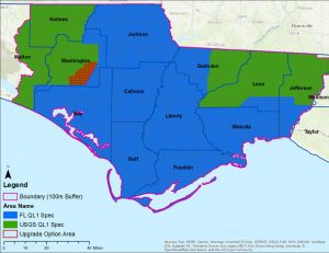
This project provides high-density lidar for more than 8,000 square miles of the Florida Panhandle with roughly 5,700 square miles of enhanced hydrographic specifications for storm surge modeling. Photo courtesy of Dewberry.