GSSI, the world’s leading manufacturer of ground penetrating radar (GPR) equipment, announces PaveScan® RDM 2.0 – an innovative asphalt density assessment tool that provides accurate real-time measurements to ensure pavement life and quality.
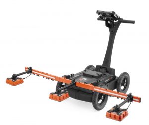
GSSI unveiled PaveScan® RDM 2.0 for the U.S. and Canada at the Transportation Research Board 2020 Conference in January. PaveScan 2.0 incorporates a new sensor design built specifically for the extremes of the asphalt paving environment, foldable deployment arms with high-visibility for work site safety and has a warm-up time of under one minute when ambient temperature is over 70° F.
PaveScan RDM is ideal for uncovering problems that occur during the paving process, including poor uniformity and significant variations in density. By avoiding these problems, PaveScan RDM helps avoid such premature failures as road raveling, cracking, and deterioration along joints.
This system automatically measures the dielectric value to identify anomalies in real-time. In addition, the dielectric values can be used to as a means to correlate percent voids and density in new pavement. The innovative technology enables users to obtain critical density data for QA/QC of new pavements. Unlike other options, like nuclear density gauges or radioactive alternatives, PaveScan does not result in any site hazards or require closing off work areas.
Seamlessly integrating with GPS systems, PaveScan features a flexible, modular design that facilitates easy and efficient operation and data collection. It is offered as a single sensor or a three-sensor cart based configuration.
As of April 2019, this pavement density measurement technology is an accepted American Association of State and Highway Transportation Officials (AASHTO) specification, PP 98-19.
About GSSI
Geophysical Survey Systems, Inc. is the world leader in the development, manufacture, and sale of ground penetrating radar (GPR) equipment, primarily for the concrete inspection, utility mapping and locating, road and bridge deck evaluation, geophysics, and archaeology markets. Our equipment is used all over the world to explore the subsurface of the earth and to inspect infrastructure systems non-destructively. GSSI created the first commercial GPR system 50 years ago and continues to provide the widest range and highest quality GPR equipment available today.
