Asian Surveying & Mapping
Breaking News
HAL to build, market Isro’s SSLV in landmark deal
New Delhi, Jun 20: In a historic move for...
Taiwan developing space capabilities for all-weather imaging
TAIPEI (TVBS News) — Taiwan is advancing its space...
Honda hails successful test of reusable rocket as it looks to get into the space business
Tokyo — Japan's second-biggest carmaker, Honda, has successfully tested...
China’s space program provides larger platform for broader international cooperation
BEIJING -- Experts from China's manned space program said...
India To Launch $1.5 Billion Joint Earth Mission With NASA In July
National Aeronautics and Space Administration (NASA) and the Indian...
Axiom-4 mission delayed again: ISRO confirms Subhanshu Shukla’s ISS spaceflight won’t launch before 22 June 2025
The Axiom-4 mission to the International Space Station has...
Mengzhou spacecraft for China’s moon-landing mission passes landmark test flight
China has completed the inaugural test flight of its...
Space application for ITMA Asia + CITME 2026 opens
Shanghai – Space application for the 2026 edition of...
Yanmar, Chia Tai and XAG Empower Thai Agriculture through Innovation
Bang Nam Priao District, Chachoengsao Province, Thailand – On...
bitsensing Signs MOU with IKIO Technologies to Advance AI-Based Traffic Monitoring on India’s Expressways, Highways and Municipal Areas
Backed by proven success in South Korea and Europe,...

March 5th, 2020
TURKEY / GREECE BORDER: Satellite Images Show Refugee Crisis

Thousands of refugees wait patiently in line at the Turkey border, as they await passage into Greece.

Satellite images captured only hours ago with WorldView-3 by European Space Imaging, show long lines of refugees on the road, numerous buses and trucks, as well as temporary housing facilities scattered adjacent to the road, extending well into the nearby forest.

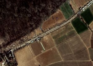
Several buses on the road towards the border are clearly identifiable, correlating with reports that refugees are being bused to the area. In addition, numerous smaller vehicles with crowds of people surrounding can be seen. This could be indicative of aid support in the area. For security and safety, the border is being closely monitored by Frontex to mitigate any crises that could arise. “We are looking at other ways to help EU countries that border Turkey,” the agency said.

“Very High Resolution satellite imagery is both a cost-effective and time-efficient method of monitoring European borders as it allows identification of small objects in near real-time,” said Adrian Zevenbergen, Managing Director, European Space Imaging. “Country borders can run across long distances of differing terrain and people are small. Monitoring these areas frequently enables us to track refugee movements in order to ensure their safety.”

European Space Imaging will continue to monitor this situation and make images available as soon as possible.