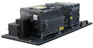
New Galaxy T2000 dual-mount lidar system enables unmatched collection efficiency and point density
VAUGHAN, Canada — September 17, 2019 — Teledyne Optech, a Teledyne Technologies [NYSE:TDY] company, and global leader in lidar sensing is pleased to announce the next evolution of its award-winning Galaxy™ platform, the Galaxy T2000. A compact lidar-mapping sensor, the Galaxy T2000 provides a unique feature set for maximum collection efficiency and point density, and is the next step in the evolution of modern aerial surveying. Coupled with a new G2 mounting system, the Galaxy T2000 leverages its compact size to co-mount two sensors over a single aircraft portal, making it quite simply the most flexible commercial lidar system on the market today.
The Galaxy T2000 boasts a 2 MHz laser emission rate directed fully to the ground by a new high frequency, programmable scanner for effective point distribution. Combined with Teledyne Optech’s patented SwathTrak™ capability, the Galaxy T2000 is capable of maintaining fixed-width data swaths in mountainous terrain via an innovative and dynamic field-of-view (FOV), enabling far fewer flight lines and more equidistant point spacing compared to fixed-FOV sensor designs.
The Galaxy T2000 also has a much narrower beam divergence at 0.16 mrad (1/e), producing higher energy density within the laser footprint. This has the advantage of further increasing ground detection in heavily forested environments. Furthermore, as point densities increase, the smaller beam footprint becomes a necessary requirement for superior target and model resolution.
“The Galaxy T2000 demonstrates our ongoing commitment to customer competitiveness and investment preservation in an active market,” said Michael Sitar, Director of Product Management at Teledyne Optech. “By offering a fully upgradeable platform with application and configuration flexibility we are able to respond quickly to market changes in technology and performance, and ensure our customers are not left behind. The T2000 is a next step in the successful Galaxy story.”
Visitors to InterGEO are invited to see the new Galaxy T2000 and G2 mount displayed from September 17-19 at the Teledyne Optech Booth in Hall 3, B3.042, at the Messe Stuttgart, Stuttgart, Germany.

About Teledyne Optech
Teledyne Optech is a part of the Teledyne Imaging Group and a world leader in high-accuracy lidar 3D survey systems, integrated cameras, and productivity-enhancing workflows. With operations and staff worldwide, Teledyne Optech offers both standalone and fully integrated lidar and camera solutions for airborne mapping, airborne lidar bathymetry, mobile mapping, terrestrial laser scanning, and mine cavity monitoring, as well as space-proven sensors. Teledyne Optech supports its clients with an around-the-clock team, on-site service, and regular efficiency enhancements to the workflow of its integrated systems.