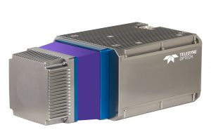
VAUGHAN, Canada — Teledyne Optech, a Teledyne Technologies [NYSE:TDY] company and global leader in advanced lidar sensors, is pleased to announce the CL-360, the next offering in its new line of compact lidar sensors for UAV and mobile applications. The CL-360 boasts survey-grade data precision that is synonymous with Teledyne Optech lidar sensors and is designed specifically to meet the needs of OEM hardware manufacturers to develop products for mobile, static, UAV or airborne surveying markets. The CL-360 joins the CL-90 in Teledyne Optech’s suite of compact high-accuracy lidar scanners.
The CL-360 captures high-density lidar points in a full 360° plane surrounding the sensor, at ranges exceeding 750 m (20% reflective target). The resulting point cloud boasts survey grade accuracy of less than 10 mm and data precision of less than 5 mm. Excellent point distribution is achieved with scan rates of up to 250 lines per second.
In addition to long-range performance, the CL-360 provides excellent vegetation penetration capability with an industry-leading 0.3mrad laser beam divergence (1/e2). Complex structure detail is further enabled by the smaller beam divergence and corresponding smaller beam footprint to provide much higher target resolution required for high-density applications, such as asset inspection and engineering projects.
“We are very excited to expand our Compact Lidar portfolio with the addition of the CL-360,” said Mark Treiber, Product Manager for Compact Lidar. “The CL-360 will form the foundation of numerous forthcoming product configurations from our OEM partners for a multitude of applications and platforms.”

About Teledyne Optech
Teledyne Optech is a part of the Teledyne Imaging Group and a world leader in high-accuracy lidar 3D survey systems, integrated cameras, and productivity-enhancing workflows. With operations and staff worldwide, Teledyne Optech offers both standalone and fully integrated lidar and camera solutions for airborne mapping, airborne lidar bathymetry, mobile mapping, terrestrial laser scanning, and mine cavity monitoring, as well as space-proven sensors. Teledyne Optech supports its clients with an around-the-clock team, on-site service, and regular efficiency enhancements to the workflow of its integrated systems.