By and large INTERGEO is an exporters delight – while many technologies are used in the German marketplace, the trade show presents some of the best that the world has to offer in the geospatial and geomatics fields to the rest of the world – and several Asian companies were present, just for that reason.
 Eternix Ltd. – Integrated Visualization Display – Tel Aviv, Israel
A few that I had a chance to speak with and some of the products that they exhibited include:
- CHC Navigation – Shanghai, China – exhibiting a range of GNSS technologies from moderate to high accuracy
- Beijing Eastdawn – Beijing, China – a reseller of high resolution satellite imagery (12 in total).
- Unistrong – Beijing, China – manufactuers 8 models of GPS (including for COMPASS)
- Changzhou Jinli Optical – Changzhou, China – manufacturer of tripod mounts for surveying and photo purposes
- Coden – Tokyo, Japan – remote control operated boat systems for hydrographic use
- Eternix – Tel Aviv, Israel – software for high resolution visualization and analysis for GIS data (this is amazingly fast)
- Suzhou FOIF – Suzhou, China – manufacturers of surveying instruments and GNSS handheld devices
- Geoquick – Jiangsu, China – surveying accessories, prism holders and telescping rods
- Group SCE India – Karnataka, India – end-to-end geospatial services company processing GIS, lidar, remote sensing and enterprise data
- Hi-Target – Guangzhou, China – manufacturer of surveying instruments including GNSS technologies
- Mitsubishi Electric – Tokyo, Japan – manufacturer of mobile mapping systems
- myzox – Aichi, Japan – long time manufacturer of surveying staffs
- Phenix – Jiangxi, China – manufacturer of surveying levels and total stations
- SETL – Tianjin, China – surveying and optical instruments including theodolites, levels and accessories
- Pentax – Tokyo, Japan – surveying equipment manufactuer including optical equipment
- Geostar – Wuhan, China – manufacturer of spatial data software for publishing, processing and 3D city models
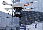
The show included many manufacturers of laser-based technologies, primarily for laser scanning. Other popular technologies at this event included UAVs (unmanned aircraft and helicopters) that are finding their way into forestry, agriculture, monitoring applications.
——————————————–
For Additional Coverage of This Event By Vector1 Media
INTERGEO 2011: Knowledge and Action for Planet Earth