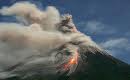
“For instance, on 28 October a Thomas Cook Scandinavia Airbus flew through the Merapi cloud en route from Indonesia to Saudi Arabia, with a stop in Batam. Once in Batam, it was discovered that the engines were damaged and had to be replaced,” reported ESA.
Tandang Yuliadi Dwi Putra of Bakosurtanal, Indonesia, Trias Aditya of UGM,Indonesia and Walter de Vries of ITC in The Netherlands presented a paper at the recent GSDI 12 in Singapore entitled ‘Making Sense of Local Spatial Data Infrastructure in Volcanic Disaster Risk Management’. Their presentation proposed the development of a prototype approach toward mitigation of volcanic events. This work had 4 conclusions:
1) Spatial data and its technologies are indispensable for Merapi volcanic risk management
2) Functionalities of a local SDI required to support risk management are the ability to provide spatial resources, access to the data, metadata information, and web services
3) Geoportal and Geospatial Web Services can be exploited to facilitatelocal agencies’ demand for collaborative work and coordination inevacuation planning
4) Evaluation of the prototype based on specific scenario got well appreciation from local agencies official
About 867 hectares of forest parks in the region have been closed due to the event, reports Antara News. And it is on that point we can begin to see large tracts of Indonesian land (including water and atmosphere) are being impacted. Other work involves sulphur dioxide measurement from the volcano. This immediately raises the question of their monitoring and management into the future.
UNOSAT earlier published topographic information for Mt.Merapi. The volcano has impacted a large area and spatial information tools for remote sensing, mapping, sensor measurement and atmospheric measurement are all part of the toolbox needed to mitigate impacts and gain a better understanding for responding effectively.


