Asian Surveying & Mapping
Breaking News
Ecolab and ITE partners to harness water management knowledge for Singapore data center engineers
SINGAPORE, 29 APRIL 2024 – Nalco Water, an Ecolab...
NASA releases satellite photos of Dubai and Abu Dhabi before and after record flooding
NASA released photos of parts of Dubai and Abu...
Singapore releases 10-year Geospatial Master Plan
Singapore has launched its new Geospatial Master Plan (2024–33),...
Japan announces plans to launch upgraded observation satellites on new flagship rocket’s 3rd flight
TOKYO (AP) — Japan’s space agency announced Friday a...
Tesla China partners with Baidu for maps to clear FSD hurdle
Amidst Elon Musk’s unannounced trip to Beijing, China this...
ESA opens ideas factory to boost space innovation in Austria
A centre to innovate the design and manufacture of...
Japan’s space agency sets June 30 as third launch date for H3 rocket
The Japan Aerospace Exploration Agency (JAXA) announced Friday that...
S. Korea launches nanosatellite for Earth observation
SEOUL- A South Korean nanosatellite was launched into orbit...
Australian Space Agency funds development of aerospace-grade GNSS receiver
The Australian Space Agency has funded the development of...
Continuity risks for Australian EO data access
A new report details the widespread use of Earth...
SMT

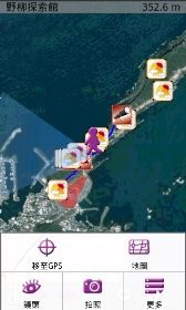
In addition to clear and intuitive interface, SuperGIS Mobile Tour 3.0 offers diverse media including text, images, video and audio for travel guide, making users browse and access vivid information of scenic spots, local hosts and websites with much ease. What’s more, its GPS navigation function can assure tourists of correct and safe routes by reminding tourists that they are approaching the dangerous area or deviating from the route. 

Another feature of SuperGIS Mobile Tour 3.0 is the simple installation process. Users can save map data and configuration file into a SD card or transmit data with a USB cable. Afterwards, the data can be installed in the handheld devices supporting .NET CF 2.0 SP2 or above. Moreover, SuperGIS Mobile Tour is integrated with GPS, GIS, AR (Augmented Reality) technologies, allowing users to intuitively tap the information on the panel.  

With rich tour information and comprehensive support functions of SuperGIS Mobile Tour 3.0, tourists are able to design and manage their journeys in a user-friendly manipulation environment.  

For more information of SuperGIS Mobile Tour 3.0, please visit www.supergeotek.com