Asian Surveying & Mapping
Breaking News
Ecolab and ITE partners to harness water management knowledge for Singapore data center engineers
SINGAPORE, 29 APRIL 2024 – Nalco Water, an Ecolab...
NASA releases satellite photos of Dubai and Abu Dhabi before and after record flooding
NASA released photos of parts of Dubai and Abu...
Singapore releases 10-year Geospatial Master Plan
Singapore has launched its new Geospatial Master Plan (2024–33),...
Japan announces plans to launch upgraded observation satellites on new flagship rocket’s 3rd flight
TOKYO (AP) — Japan’s space agency announced Friday a...
Tesla China partners with Baidu for maps to clear FSD hurdle
Amidst Elon Musk’s unannounced trip to Beijing, China this...
ESA opens ideas factory to boost space innovation in Austria
A centre to innovate the design and manufacture of...
Japan’s space agency sets June 30 as third launch date for H3 rocket
The Japan Aerospace Exploration Agency (JAXA) announced Friday that...
S. Korea launches nanosatellite for Earth observation
SEOUL- A South Korean nanosatellite was launched into orbit...
Australian Space Agency funds development of aerospace-grade GNSS receiver
The Australian Space Agency has funded the development of...
Continuity risks for Australian EO data access
A new report details the widespread use of Earth...

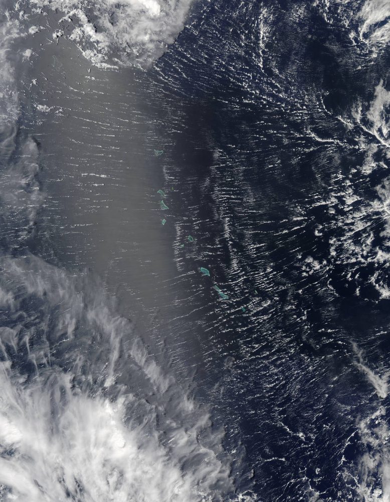
Areas near the equator are frequently cloudy, obscuring the view of Earth’s surface from space. April 7, 2017, was no different. On that day, the Moderate Resolution Imaging Spectroradiometer (MODIS) on NASA’s Terra satellite captured this natural-color image of clouds over the Gilbert Islands. The remote island chain is part of the Republic of Kiribati, and straddles the equator in the central Pacific Ocean.

These clouds, however, were not a typical tropical rainstorm. Instead, the parallel “roll clouds” were likely influenced by the development of Tropical Cyclone Cook to the south. At the time, Cook was strengthening near Vanuatu and heading toward New Caledonia.

“As far as tropical cyclones go, we believe that they are a nearly ideal environment for roll formation,” said Ralph Foster, an atmospheric scientist at the University of Washington. The extreme wind shear associated with cyclones generates additional turbulence in the already turbulent layer of air near Earth’s surface. According to Foster, the turbulent flow in this layer “self-organizes,” forming long rolls of counter-rotating air.

More precisely, the atmosphere has alternating clockwise and counterclockwise circulation. In between the overturning circulations are updrafts and downdrafts. If conditions are right for clouds to form, clouds will grow in the updraft zone and be suppressed in the downdraft. The resulting linear cloud features can persist for hours.

This MODIS image shows parallel “roll clouds” that likely were influenced by the development of Tropical Cyclone Cook to the south. (Credit: NASA image by Jeff Schmaltz, LANCE/EOSDIS Rapid Response)