The Mekong River Commission was established with a goal to ““to promote and co-ordinate sustainable management and development of water and related resources for the countries”. It includes most countries along the river with the exception of China and Burma.
The Commission has developed a Water Commission Program whose responsibilities included the development of procedures for water use along the river. These resulted in the Framework for Decision Making.
“The Decision Support Framework is a suite of modelling tools capable of describing changes in river flow and assessing impacts that can occur as a result of land cover change, infrastructure development – mainly for irrigation and hydropower – and climatic variations within the basin. An important conclusion of the DSF is that it shows the Mekong flow regime to be highly robust: with good planning and management, there is much room for water resource developments that benefit all Member States and contribute to poverty reduction.“
Although that membership group has ended, the framework survives and continues to guide the orientation of policy and water use within the regions of the Mekong River.
A significant amount of work along the Mekong River has engaged the use of satellite sensors. IKONOS, SPOT, MODIS, ENVISAT, ASTER, Landsat and others have all been used and continue to provide up-to-date satellite imagery along the river’s length. No less than 67 new fish species have been found in the river.
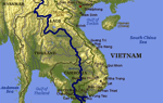
Surveying has continually taken place along the Mekong River, particulaly in those areas between Thailand and Laos where the river forms the border. Changes in that delineation obviously expose major concerns between the two countries.
A major baseline survey report for the Mekong River basin was conducted and printed in 2005. Other engineering related projects including bridges, roads, power generation and other activities have also included the use and application of geospatial tools. Other projects include the Greater Mekong Subregion Southern Coastal Corridor.
Managing the length of the Mekong River is critical for numerous reasons. These include the use of water, but also for reasons associated with territorial peace to ensure cooperation and maintenance of the biodiversity and values of this long and important river of Asia.


