Asian Surveying & Mapping
Breaking News
Ecolab and ITE partners to harness water management knowledge for Singapore data center engineers
SINGAPORE, 29 APRIL 2024 – Nalco Water, an Ecolab...
NASA releases satellite photos of Dubai and Abu Dhabi before and after record flooding
NASA released photos of parts of Dubai and Abu...
Singapore releases 10-year Geospatial Master Plan
Singapore has launched its new Geospatial Master Plan (2024–33),...
Japan announces plans to launch upgraded observation satellites on new flagship rocket’s 3rd flight
TOKYO (AP) — Japan’s space agency announced Friday a...
Tesla China partners with Baidu for maps to clear FSD hurdle
Amidst Elon Musk’s unannounced trip to Beijing, China this...
ESA opens ideas factory to boost space innovation in Austria
A centre to innovate the design and manufacture of...
Japan’s space agency sets June 30 as third launch date for H3 rocket
The Japan Aerospace Exploration Agency (JAXA) announced Friday that...
S. Korea launches nanosatellite for Earth observation
SEOUL- A South Korean nanosatellite was launched into orbit...
Australian Space Agency funds development of aerospace-grade GNSS receiver
The Australian Space Agency has funded the development of...
Continuity risks for Australian EO data access
A new report details the widespread use of Earth...

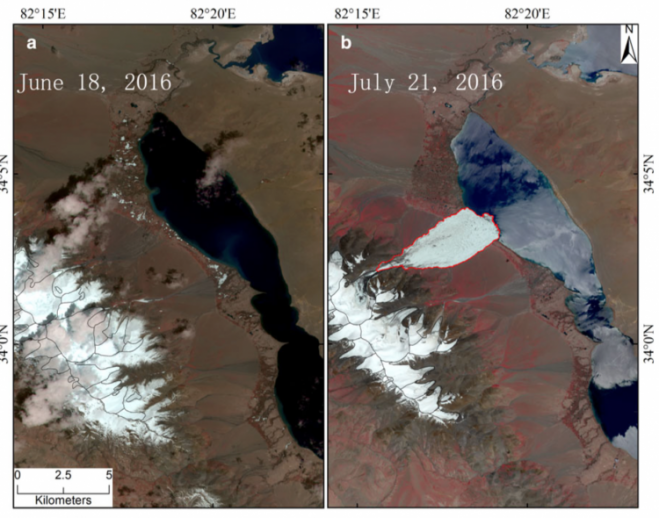
The Journal of Glaciology recently published the first account from scientists at the Institute of Tibetan Plateau Research of the Chinese Academy of Sciences (ITPCAS) concerning a glacier that collapsed on July 17, 2016, killing nine local yak herders. Eyewitnesses reported the episode lasted only four to five minutes, but more than 70 million cubic meters of ice tumbled down a mountain valley, spreading across 6 kilometers of the lowland below.

ESA’s Sentinel-2 satellite recorded “before and after” 10-meter-resolution images of the Aru Glacier collapse on July 17, 2016. (Credit: ESA/Sentinel-2)

ESA’s Sentinel-2 satellite recorded “before and after” 10-meter-resolution images of the Aru Glacier collapse on July 17, 2016. (Credit: ESA/Sentinel-2)

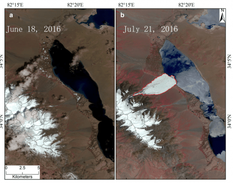
On Sept. 21, 2016, a neighboring glacier to the southeast collapsed. Although there were no deaths, the volume of ice released was even larger than in the first collapse.ESA’s Sentinel-2 satellite recorded “before and after” 10-meter-resolution images of the Aru Glacier collapse on July 17, 2016. (Credit: ESA/Sentinel-2)

“Unusually heavy snowfalls in the months before the collapses must have played a role,” noted Lide Tian of ITPCAS, lead author of the scientific paper. “Large amounts of resulting meltwater may have found their way to the glacier bed or to some surface of structural weakness within the ice. There the meltwater would have reduced frictional drag and triggered the collapses.”