Asian Surveying & Mapping
Breaking News
HAL to build, market Isro’s SSLV in landmark deal
New Delhi, Jun 20: In a historic move for...
Taiwan developing space capabilities for all-weather imaging
TAIPEI (TVBS News) — Taiwan is advancing its space...
Honda hails successful test of reusable rocket as it looks to get into the space business
Tokyo — Japan's second-biggest carmaker, Honda, has successfully tested...
China’s space program provides larger platform for broader international cooperation
BEIJING -- Experts from China's manned space program said...
India To Launch $1.5 Billion Joint Earth Mission With NASA In July
National Aeronautics and Space Administration (NASA) and the Indian...
Axiom-4 mission delayed again: ISRO confirms Subhanshu Shukla’s ISS spaceflight won’t launch before 22 June 2025
The Axiom-4 mission to the International Space Station has...
Mengzhou spacecraft for China’s moon-landing mission passes landmark test flight
China has completed the inaugural test flight of its...
Space application for ITMA Asia + CITME 2026 opens
Shanghai – Space application for the 2026 edition of...
Yanmar, Chia Tai and XAG Empower Thai Agriculture through Innovation
Bang Nam Priao District, Chachoengsao Province, Thailand – On...
bitsensing Signs MOU with IKIO Technologies to Advance AI-Based Traffic Monitoring on India’s Expressways, Highways and Municipal Areas
Backed by proven success in South Korea and Europe,...
Kinman

For many years, Kinmen National Park has collected a large sum of geographic data related to this land. However, in some cases, the data format fails to conform to the system for data coordinating, thus seriously affecting the efficiency of the data management. To optimize the management of land resources and to maintain public facilities in Kinmen National Park, the administration decided to establish a Geographic Information System (GIS).

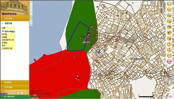
“Kinmen National Park Spatial Data Management GIS” is a management system based on SuperWebGIS, the Internet Map Server software developed by SuperGeo Technologies. It contains five major functions, including query and position, user account management, file management, data output and map data display.

By utilizing substantial map resources and WebGIS technologies, this system can notably improve the management regarding the spatial data of Kinmen National Park, such as map display, query and position with map and text, output of map and data. With the “Kinmen National Park Spatial Data Management GIS” system, the staff of the national park can easily and properly manage the land resources on a unified platform. Moreover, the recreation quality is anticipated to gain considerable elevation in the long term.

More information is available at http://www.supergeotek.com/Library_2_201103.aspx