
Asian Surveying & Mapping
Breaking News
ISRO Maps Over 2,000 Glaciers, 3,219 Glacial Lakes in Ladakh for Disaster Management
SRINAGAR: The Indian Space Research Organisation (ISRO) and other...
China Closes the Satellite Gap in Space Race With the U.S.
China aims to match the U.S. as the world’s...
IIT-Tirupati hosts fifth BRICS working group meeting on geospatial technologies
The Indian Institute of Technology-Tirupati (IIT-Tirupati), in collaboration with...
South Korea launches 4th Earth observation satellite from US
South Korea on Tuesday launched its fourth Earth observation...
Korea AeroSpace Administration Unveils K-Space Vision
Agency Will Benchmark European Aerospace Clusters and Explore Joint...
Japan space agency conducts Epsilon rocket engine test after failures
TOKYO - The Japan Aerospace Exploration Agency on Thursday...
UAE to boldly go with programme to boost nation’s expertise in space sector
A programme has been announced to enhance Emirati expertise...
China is building a ‘Mach 26 asteroid hammer’ to strike space rocks before they hit Earth
The Earth revolves in a cosmic system which is...
Nigeria and Benin Strengthen Border Surveillance with Geospatial Technology
The partnership was highlighted during a strategic meeting at...
IIT-Tirupati hosts fifth BRICS working group meeting on geospatial technologies
The Indian Institute of Technology-Tirupati (IIT-Tirupati), in collaboration with...

April 4th, 2011
Leica FPES v10.2: New Features for Efficient Planning and Cost-effective Flights

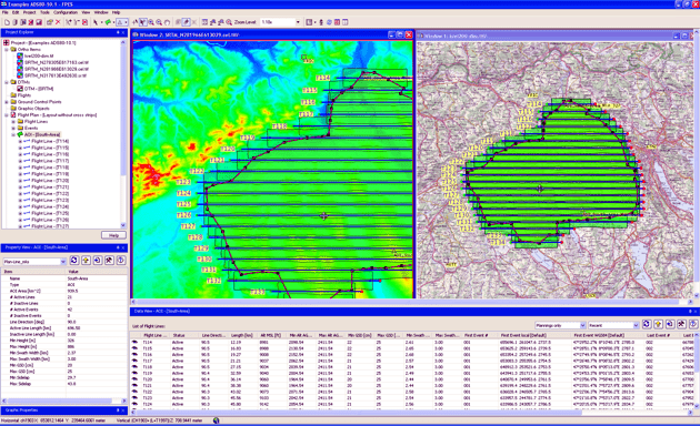
Leica_FPES10-2-Overview_flight_lines

Version 10.2 of Leica FPES provides enhanced planning features like graphical definition of the line direction or cutting groups of lines. The height range for elevation encoded color images can now be defined and Leica FPES v10.2 can also detect the minimum and maximum elevation in a DTM area, an AOI or in flight line footprints. New computation options allow to take the terrain height outside the AOI into account and coordinate systems of existing flight plans can be changed to merge flight plans together. Also many new QC features are implemented and the Flight Line Investigator is enhanced. Leica FPES v 10.2 frame flight plans can be exported now in the format for execution with Z/I Inflight.


Additionally Leica FPES v10.2 has incorporated a significantly enhanced AeroPlan for flight planning with Leica ALS sensors. The new AeroPlan70 provides graphical presentation of the computation results, includes one additional point density optimization method and the possibility to compute for multi-sensor configurations frame camera parameters that match the ALS settings. Furthermore, AeroPlan70 supports the recently announced Leica ALS70 airborne laser scanner.  

Availability

Leica FPES v10.2 is available immediately and ready for download for Customers of Leica FPES which are on Software Maintenance.