Asian Surveying & Mapping
Breaking News
Launch of Australia’s 1st orbital rocket, Gilmour Space’s Eris-1, delayed again
Update for 6:15 p.m. ET on July 1: Gilmour Space...
SAASST, UAE Space Agency strengthen scientific partnership
SHARJAH- Prof. Hamid M.K. Al Naimiy, Director of the...
Shubhanshu Shukla to speak to students and ISRO scientists this Friday
Indian astronaut Shubhanshu Shukla will interact with school students...
ISRO hands over 10 advanced technologies to Indian firms in major push for space commercialisation
The Indian Space Research Organisation (ISRO) has transferred ten...
DIGIPIN Launched: India Embraces Geospatial Precision in Digital Addressing
IIT Hyderabad (IITH), in partnership with the Department of...
HAL to build, market Isro’s SSLV in landmark deal
New Delhi, Jun 20: In a historic move for...
Taiwan developing space capabilities for all-weather imaging
TAIPEI (TVBS News) — Taiwan is advancing its space...
Honda hails successful test of reusable rocket as it looks to get into the space business
Tokyo — Japan's second-biggest carmaker, Honda, has successfully tested...
China’s space program provides larger platform for broader international cooperation
BEIJING -- Experts from China's manned space program said...
India To Launch $1.5 Billion Joint Earth Mission With NASA In July
National Aeronautics and Space Administration (NASA) and the Indian...

satellite images

image

Sunday, March 13th, 2011

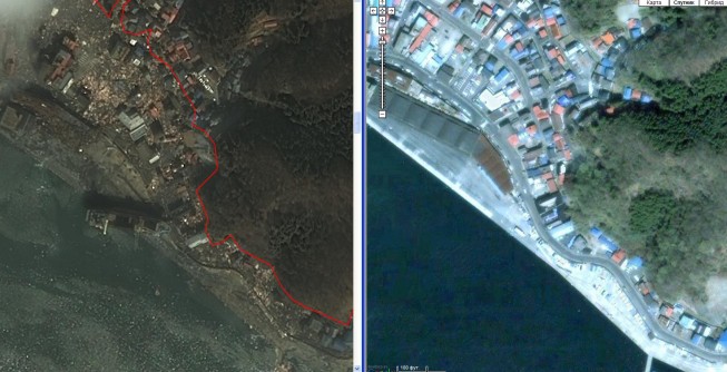
Earthquake in Japan: Detailed Satellite Images Received

Detailed satellite images of the territory of Japan were received, where a series of earthquakes were registered on March 11 in its north-eastern parts. According to the Main Meteorological Service of the country the 8.9 magnitude earthquake...

Tuesday, March 8th, 2011

Libya: Satellite Images Show Refugee Crisis

Satellite pictures showing the extent of Libya’s refugee problem have emerged. The GeoEye-1images reveal a mass of people at the Ras Ajdir crossing at Libya’s border with Tunisia. But they only indicate scale, not detail. The satellite pictures taken on...

Tuesday, February 1st, 2011

Space Images – Used to Find “Partner” Schooner

Satellite radar imagery data was used to find the “Partner” fishing schooner lost in the Sea of Japan. According to Russian EMERCOM the area search operations for the “Partner” schooner that sent a distress call on January...

Friday, January 28th, 2011

Terralook Version 2.0 (beta) Software Released

TerraLook provides easy access to new and historical satellite images for users that lack experience with satellite images, or for anyone looking for a convenient way to obtain and work with these images. Formerly known as the...

Thursday, January 20th, 2011

ISRO To Provide Satellites Images for Sabarimala

The Indian Space Research Organisation (ISRO) will provide the satellite images of Sabarimala to the State Government for the infrastructure development of the area in a bid to prevent disasters such as Pulmedu stampede in...

Page 2 of 2 1 2