Thursday, August 13th, 2015
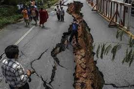
Crowdsourcing has added a new dimension to Nepal’s disaster response capability following the massive earthquake that struck this Himalayan country on 25 April, killing more than 8,000 people, injuring thousands and leaving tens of thousands displaced. Government...
Wednesday, May 27th, 2015
FOSS4G Seoul 2015 Committee is pleased to announce to sign Memorandum of Understanding (MOU) with Smart Geospatial Expo Organizing Committee to closely cooperate FOSS4G Seoul 2015 and SmartGeo Expo 2015 all together including co-promotion of two events,...
Tuesday, February 24th, 2015
Feb. 22, 2015—After many years of development the new stable major release GRASS GIS 7.0.0 is available. The graphical user interface based on wxPython has been enriched with many new features in order to make complex GIS operations...
Tuesday, October 28th, 2014
The gvSIG-Training e-Learning platform opens its registration period for the "Basic GIS with gvSIG" MOOC in English, given by the gvSIG Association and GISMAP. This MOOC aims to show the use and potentiality of the open source software...
Monday, September 30th, 2013
At the code sprint following the FOSS4G 2013 conference, rapidlasso GmbH completed a toolbox that exposes the extensive LiDAR processing capabilities of the LAStools software suite within QGIS. QGIS (previously known as "Quantum GIS") is a comprehensive...
Thursday, September 5th, 2013
The tide is turning with the use of open-source software within the Australian government, according to the chief technology officer John Sheridan, with departments shifting from buying proprietary software to buying support for open-source software. There has...
Thursday, August 8th, 2013
There is a growing community of amateur Umanned Aerial Vehicle (UAV) developers and builders that are using open source hardware and software to capture aerial imagery. The primary website for this emerging marketplace is DIY Drones,...
Monday, July 22nd, 2013
The University of Melbourne will be home to Australia’s first Open Source Geospatial Laboratory. The laboratory will support urban research and educational excellence through the use of location based (geospatial) data and tools.
Thursday, June 20th, 2013
The City of Pune, India is undertaking an ambitious tree mapping project that aims to enlist the population in determining tree location, species, size as well as photographs across the whole city. This pilot tree census uses...
Thursday, May 30th, 2013
National ICT Australia (NICTA) has developed a web-based global mapping tool that works in web browsers without a plugin. The sytem is known as Subspace, and it's an open source sytem that builds on the Cesium geo...