Asian Surveying & Mapping
Breaking News
Launch of Australia’s 1st orbital rocket, Gilmour Space’s Eris-1, delayed again
Update for 6:15 p.m. ET on July 1: Gilmour Space...
SAASST, UAE Space Agency strengthen scientific partnership
SHARJAH- Prof. Hamid M.K. Al Naimiy, Director of the...
Shubhanshu Shukla to speak to students and ISRO scientists this Friday
Indian astronaut Shubhanshu Shukla will interact with school students...
ISRO hands over 10 advanced technologies to Indian firms in major push for space commercialisation
The Indian Space Research Organisation (ISRO) has transferred ten...
DIGIPIN Launched: India Embraces Geospatial Precision in Digital Addressing
IIT Hyderabad (IITH), in partnership with the Department of...
HAL to build, market Isro’s SSLV in landmark deal
New Delhi, Jun 20: In a historic move for...
Taiwan developing space capabilities for all-weather imaging
TAIPEI (TVBS News) — Taiwan is advancing its space...
Honda hails successful test of reusable rocket as it looks to get into the space business
Tokyo — Japan's second-biggest carmaker, Honda, has successfully tested...
China’s space program provides larger platform for broader international cooperation
BEIJING -- Experts from China's manned space program said...
India To Launch $1.5 Billion Joint Earth Mission With NASA In July
National Aeronautics and Space Administration (NASA) and the Indian...

Mapping

image

Tuesday, December 13th, 2011

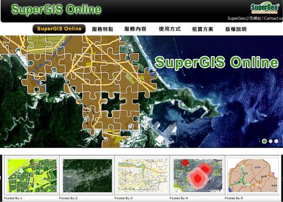
SuperGeo Announces SuperGIS Online Website

SuperGeo announces that SuperGIS Online Website is officially launched, making the GIS data and services accessible through the Internet.

Saturday, December 10th, 2011

Indigenous Indian Space Technology at Par With Others

At an event hosted by a private college to commemorate the launch of Polar Satellite Launch Vehicle (PSLV) C-18, Associate Director of Thiruvananthapuram based Vikram Sarabhai Space Center, John P Zachariah said that indigenous Indian space technology...

Saturday, December 10th, 2011

Maintain KNN’s Standard: Municipal Commissioner

Kanpur Nagar Nigam (KNN) has won an award for creating unique geographical information system (GIS), designed to locate the houses in the city.  Municipal commissioner R Vikram Singh praised the efforts of the staff and emphasized to maintain standards in...

Wednesday, December 7th, 2011

FOIF Exhibits Surveying Technologies In Fuzhou

The first national mapping of geographic information technology and equipment exhibition in Fuzhou, Fujian Strait International Convention and Exhibition Center, attracted a field of surveying and mapping technology including nearly 200 enterprises. The exhibition organized by the China...

Wednesday, December 7th, 2011

GLONASS Becomes Widely Used by Mobile Device Producers

The Russian head of the Ministry of Communications and Mass Media Igor Schegolev announced that a significant number of mobile device producers have started using GLONASS-enabled navigational chips, Rossiyskaya Gazeta writes. Quote "Two navigational systems are better...

Tuesday, December 6th, 2011

Nokia Develping 3-D Mapping for Use in Buildings

Nokia has demonstrated a new indoor 3D mapping system that might change the way people navigate in inside a building, a mall or airport. According to an article on Into Mobile, even as Google tries to introduce...

Tuesday, December 6th, 2011

Singapore Satellite Positioning Reference Network

The Singapore Satellite Positioning Reference Network, SiReNT is a nation-wide reference network developed to support real-time high precision land surveying and other positioning applications. An initiative by Singapore Land Authority (SLA), SiReNT provides Differential GPS (DGPS) services...

Tuesday, December 6th, 2011

China Global Investment Tracker Interactive Map

China's investment overseas is increasingly important to the United States and the international community. The China Global Investment Trackercreated by The Heritage Foundation is the only publicly available, comprehensive dataset of large Chinese investments and contracts worldwide beyond...

Tuesday, December 6th, 2011

IIC Announces the Award of a Contract from Land Information New Zealand

IIC is pleased to announce the award of a contract from Land Information New Zealand (LINZ) for the production of 50 paper chart masters using Citrix technology and CARIS HPD.  The production work will continue until mid-2012...

Tuesday, December 6th, 2011

New Zealand Geospatial Strategy

The New Zealand Geospatial Strategy, published in January 2007, aims to better coordinate and manage the use of New Zealand's geospatial resources across all tiers of society. It addresses the increasing reliance on geospatial information in New...

Page 24 of 66 1 19 20 21 22 23 24 25 26 27 28 29 66