Asian Surveying & Mapping
Breaking News
Japan’s space agency to advance earthquake damage estimation programme
Tokyo: Japan’s Aerospace Exploration Agency (JAXA) has signed an...
Taiwan-made PARUS-T1 CubeSat launched into space orbit: Space agency
Taipei, Jan. 15 (CNA) A CubeSat designed and made...
China launches Earth observation satellite for Pakistan
HELSINKI — China launched the first satellite of a...
UAE space company launches earth-monitoring craft
Space42, a space technology company that has its headquarters...
ISRO successfully executes SpaDeX docking experiment; India joins elite club of nations
The Indian Space Research Organisation (ISRO) in the early...
APAC region gaining local access to ScanFish ROTV rental and support
Singapore 15 January 2025 With a rapid increase in...
Space42’s Thuraya 4 Satellite Successfully Launched Into Orbit
ABU DHABI, UAE and CAPE CANAVERAL, Fla. —   Space42 (ADX:...
SIIS Signs MOU with Pixxel to Introduce Hyperspectral Satellite Data in Korea
Seoul, South Korea; Jan. 7, 2025: SIIS Co., Ltd....
ISRO Launches Historic SpaDeX Mission for Space Docking
ISRO successfully launched the SpaDeX mission on December 30,...
Chinese firm deploys satellite-to-ground laser communications, outpacing Starlink
A Chinese firm has surpassed Starlink by deploying satellite-to-ground...

International Charter

Thursday, October 13th, 2011

New Zealand Oil Spill Triggers Aerial Surveillance Charter

The break-up of a stranded cargo ship on the Astrolabe Reef in New Zealand has triggered the International Charter for Space  and Major Disasters. With cracks appearing the hull, and an estimate 1,900 tonnes of oil and...
Wednesday, March 16th, 2011

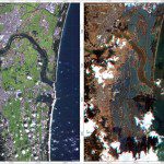
Mapping Japan’s Changed Landscape from Space

The images were acquired by the German Optical RapidEye and radar TerraSAR-X satellites. They show Torinoumi on the eastern coast of Japan before the disaster on 5 September 2010 and after the tsunami on 12 March 2011....