
TrueView Product Line Expands with Two New Starter, Survey Grade LiDAR Systems.
FOR IMMEDIATE RELEASE: February 10, 2025
Denver, CO – Today, live from the floor of Geo Week 2025, GeoCue is excited to announce the launch of two new groundbreaking products in the TrueView lineup: the TV1 Lite and the TV1. These new, survey-grade drone LiDAR scanners bring precision and affordability to the forefront of the geospatial industry, making high-tech drone surveying accessible to all.
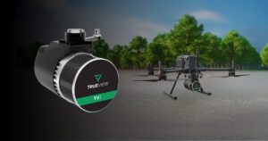
The TV1 integrated with the DJI 350 Drone
TV1 Lite: The Most Accessible Way to Get Serious About LiDAR
The TrueView 1 Lite, GeoCue’s most accessible LiDAR sensor yet, is designed to bring survey-grade accuracy to all. For just $18,990, customers receive the TrueView 1 Lite along with a full year of TV1 Lite Annual Processing, complete with comprehensive support and maintenance. This performance is powered by the innovative TrueNav, with a proven Hesai, 32 channels laser scanner, and a FLIR 5MP Global Shutter Camera with a 90º FOV. After the first year, users can continue to benefit from an easy annual renewal.
“The TV1 Lite makes cutting edge LiDAR technology available for almost everyone,” said Frank Darmayan, CEO of GeoCue. “We’re committed to expanding professional LiDAR solutions that are not only advanced but also attainable, ensuring every professional can leverage the power of precise data collection. This is the ultimate starter solution for anyone looking to step into the world of precise mapping without the high cost.”
TV1: Customizable and Budget-Friendly LiDAR Solution
The TrueView 1, on the other hand, offers customizable options starting with a choice of a 26 MP, 45 MP, or 61 MP camera. You can then choose the Trajectory Correction Service with either the Single Base processing Option, for PPK, or the Complete/No Base Station processing option, with Trimble PP-RTX unlimited trajectory processing, removing potential errors associated with using a Base Station. Included in the annual plan is LP360 Drone software processing, along with ongoing maintenance and support.
“The TrueView 1 affords you the flexibility to create the system best suited for your work. By adding these new options to our product line, we are expanding our LiDAR footprint and demonstrating that TrueView systems offer a complete solution, from hardware to software, including data collection and deliverable creation. This is a testament to our commitment to providing not just tools, but solutions that include support and training to ensure success for our users,” stated Vivien Heriard Dubreuil, CEO of GeoCue’s parent company, mdGroup.
Affordable Financing Makes Cutting-Edge Technology Accessible
To make it even easier to get started, GeoCue introduces TrueFinancing for the TrueView 1 Lite, making it incredibly accessible with a low $8,990 initial down payment and manageable monthly installments.
Vincent Legrand, Vice President of Sales at GeoCue, commented on the new financing option, “TrueFinancing is a game-changer. Starting at $8,990, professionals can access the best in drone LiDAR technology, making it faster than ever to achieve a return on investment. We’re proud to make this level of technology accessible to more users than ever before.”
Designed and Assembled in the USA, Supported Globally
Both systems, including the software, are proudly designed and assembled in Huntsville, Alabama, and come with the promise of unmatched local support. GeoCue’s dedication to supporting its products with extensive training and customer service sets it apart in the industry.
Open the Door to New Business Opportunities
The TV1 Lite and TV1 give you the power to expand services, take on more complex projects, and conquer new markets—all without draining your resources. Thanks to GeoCue’s industry-leading data processing support, you can generate the deliverables you need with confidence.
Whether you’re aiming for an accessible, robust LiDAR package or need a more flexible, upgradable solution, GeoCue’s TrueView 1 Lite and TrueView 1 can help anyone get started with professional drone LiDAR.
About GeoCue
GeoCue brings geospatial experts the very best in drone, mobile and land surveying equipment, geospatial point cloud software, workflow, training, and support for high-accuracy LiDAR and Imagery mapping to help civil engineering and surveying professionals achieve successful data collection, processing, and management.
With TrueView LiDAR/Imaging sensors and LP360 point cloud data processing software, we are the leader in LiDAR mapping processing in North America able to meet customers where they are in terms of technology, adoption, budget, and resources.
To learn more about GeoCue, visit www.geocue.com.
